


February 1, 2025 Saturday Weather Update
Will the cold pool ever escape the Pacific Northwest?

Good Evening!
Welcome to February. While the likelihood of extreme cold in mid-February is still low, I’d like to show the recent ECMWF 12z update to highlight what high-end potential might be for extreme snow and cold. Then, we need to ask if we’re heading into that type of flow-regime with the stratosphere split — strong co-located tropospheric polar vortex over the Lower 48. I’d say 1-in-4 chance right now for much below normal temperatures surging out of the Pacific Northwestern and Northern Rockies cold pool.
Regardless, we’ll watch the model updates everyday and perhaps detect a trend that will help determine the outcome in the coming days.
HRRR simulated radar next 48-hours

All of the Pacific moisture is surging eastward and will pile up on the mountains by the foot. HRRR 48-hours had 12-feet maximum somewhere — perhaps the Sierra or somewhere in Wyoming. The ski resorts will be ecstatic with the amount of snowfall coming in the next 2-weeks.

Monday, 6-8” of new snowfall — system snow — will fall around Green Bay to Traverse City, Michigan.

NWS Snowfall Next 72-hours

Still some light snowfall in New England on the way.
Precipitation Type and MSLP Next 15-days

Zooming out to show all of North America precipitation type and MSLP to get a sense of the storm tracks over the next 2-weeks. Very busy pattern with an active subtropical stream + Pacific moisture. Any low pressure center will have plenty of opportunity to combine the moisture with Arctic cold stranded north of the Canadian border to dump plenty of snowfall.
NWS WPC Precipitation | Next 7-days
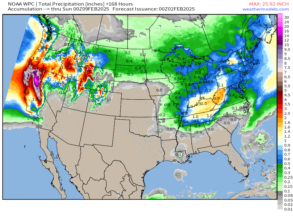
Pineapple Express rainfall in the foothills will top out at 26-inches in the next 7-days.

ECMWF AIFS 12z | Upper-Level Pattern Next 10-days
Keep reading with a 7-day free trial
Subscribe to Weather Trader to keep reading this post and get 7 days of free access to the full post archives.