


December 5, 2023
Still watching strong winter storm into Great Lakes this weekend
The 5th of the month is ECMWF Seasonal forecast day.
The strong El Nino continues into the Winter 2023-2024. A lot of red on the Dec/Jan/Feb 2023-24 seasonal temperature anomaly map meaning well above normal temperatures. That’s not a surprise. There will still be bouts of cold weather, but not sustained. That’s a consequence of the prevailing weather patterns e.g. jet stream in the coming weeks that favor warmer, Pacific origin air.

Outside of the tropics, the precipitation anomaly patterns on the seasonal scale show weak signals. That’s the complete opposite in the tropics as the Western Pacific warm pool sees huge positive rainfall anomaly. Good news is that Brazil and Argentina are somewhat green. Very, very dry across the Philippines and Australia and the equatorial eastern Indian Ocean due to +IOD (Indian O Dipole).

Wednesday Significant Weather
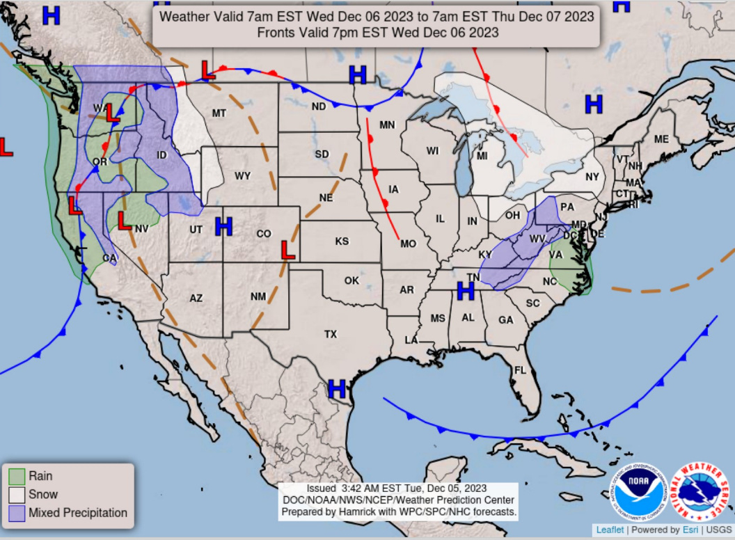
Weak Alberta Clipper continues across the Ohio Valley into the Northeast on Wednesday with generally light precipitation.
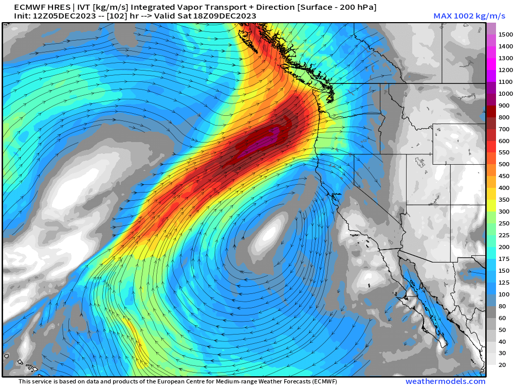
Atmospheric river onslaught across the Pacific Northwest finally takes a break before another major event this weekend. The IVT is at the high end!
Wednesday Morning Low Temperatures

The Lower 48 average low temperature is 33°F but seasonable for early December.
Tuesday Afternoon High Temperatures

Warming trend across the Plains into the 60s and 70s. Great Lakes and Northeast mainly in the 30s.
The warmest weather is in the Southwest including California.
Temperature Outlook Next 2 Weeks
The cooler than normal temperatures across the Gulf Coast and Southeast seem to be related to cut-off lows parading around the ridge anchored over Arctic Canada for the next 2-weeks.
Week 1: December 5 - December 12 [EPS Mean 12z]

Week 2: December 12 - 19 [EPS Mean 12z]

10-day Snowfall ECMWF EPS [median] and Probability of 3-inches of snowfall


The ensembles might not be as useful for this upcoming powerful winter storm because of the very narrow band of heavy snowfall in the cold sector on the backside of the low pressure. We can see from the HRES through 10-days that narrow but heavy band as well as wintry weather into New Mexico and Texas around December 14-15.


These HRES precipitation type and 850 mb wind maps show a very strong system with risk of damaging winds along the East Coast in the warm sector of the storm. Blizzard conditions over Ontario seem like the most extreme impact on Sun/Mon. However, the track of the low is uncertain and these snow bands will shift.

7-Day Precipitation Outlook

Plenty of rainfall (and snow) east of the Mississippi heading into weekend and early next week. A nice 1-inch+ across many states. Pacific NW gears up for a mega-Atmospheric river this weekend on top of the abundant rain/snow seen so far this week.
2023-2024 Global Tropics
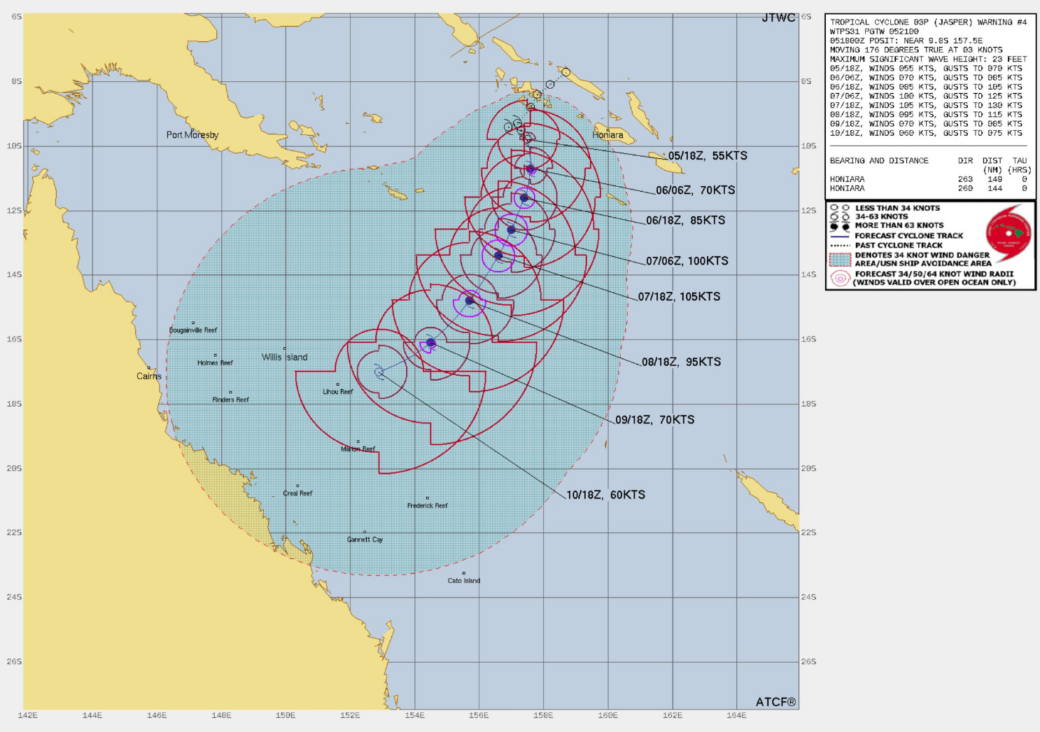
Invest 92P has been named Tropical Cyclone Jasper (03P) in the Coral Sea. JTWC forecast shows maximum intensity over 100-knots (Major/Category 3) but no imminent threat to land. At the end of the 5-day forecast period, Jasper is expected to weaken to a tropical storm.
Thank you to my paying subscribers! Your support pays for my Linux servers and product development. Also, it allows me to provide unfiltered commentary on scientific topics on X. Feel free to say hello and follow on X/Twitter (@RyanMaue)
Thank you for these insights into the weather ahead.