


December 31, 2024 Tuesday Winter Update
Strong winter storm early next week across Ohio River Valley

Special Holiday Offer [ends today] to Subscribe or Upgrade to Annual plan for 20% off. Your support is important for research, development, and growth of this platform into 2025.
Good morning! While the calendar says this is the last day of 2024, the Earth’s seasons, weather and climate won’t notice as the atmosphere/ocean system operates on a multitude of time scales. Of course, the annual cycle is important for renewal and wiping the slate clean in some respects. Heat is removed from the oceans in the middle-latitudes through radiational cooling to the atmosphere above helping to fuel storms. While we experience [extreme] weather on shorter time scales from hours, days to maybe a week, the ocean operates much slower with a longer memory.
I am fascinated with climate variability and believe that much progress will be made with A.I. tools in the coming few years to better understand the year-to-year changes we experience like El Nino, volcanic eruptions, and Pacific/Atlantic multidecadal variability.
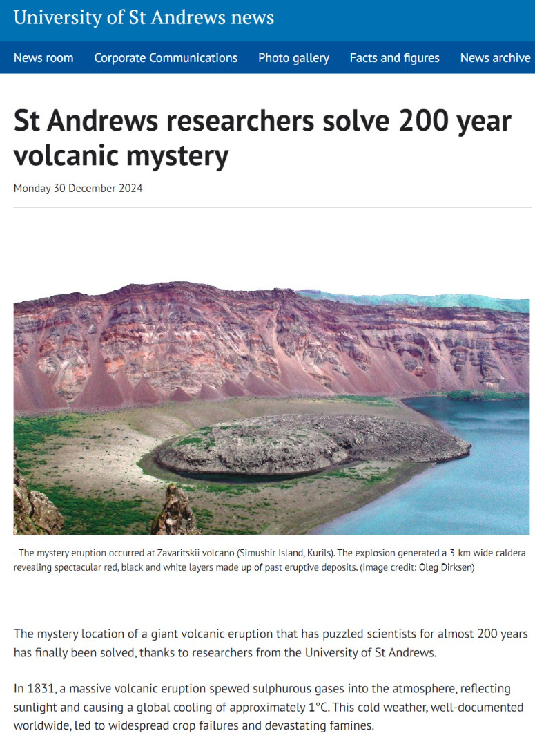
Even today, we are still solving mysteries from 200 years ago! Researchers at University of St Andrews used ice cores to pinpoint the location of a previously hidden volcanic eruption in the Kuril Island mountains south of the Kamchatka Peninsula. The massive eruption led to global cooling of 1°C and disruption to crops.
The Hunga-Tonga underwater volcano eruption in January 2022 spewed an enormous amount of water vapor into the stratosphere where almost all of it remains today. While climate modeling and research takes a long time, I think we’ll start to learn more about how this unprecedented event has affected the Earth’s climate in the past 2-3 years.
Best wishes for 2025!
Weather Headlines for Tuesday
Storm system tracking through Ohio River Valley will bring snowfall to the Great Lakes but also heavy rainfall to the Northeast including NYC. New Years festivities in Times Square could see thunderstorms!


Radar Simulation Next 18-hours | Through Midnight

At Midnight — snowfall in Detroit and across Michigan with a mixed bag of slop. Rain and thunderstorms ahead of the low track into Philly, NYC, and Boston before and after midnight.
Colder air behind the storm system will set up some Lake Effect snowfall.
The Pacific Northwest will see a frontal boundary with more coastal rain and mountain snows.

Total Rainfall over the Next 36-hours from this Northeast storm system: 0.5” to maybe 1”.

Over the next 3-days, Lake Effect snow machine cranks back up

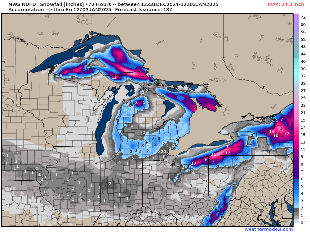
But also could be some lighter snowfall (1-2”) from Des Moines through Indianapolis and Columbus with a weak system by Thurs/Friday.

Temperature Anomaly (Ensemble Mean) next 15-days:
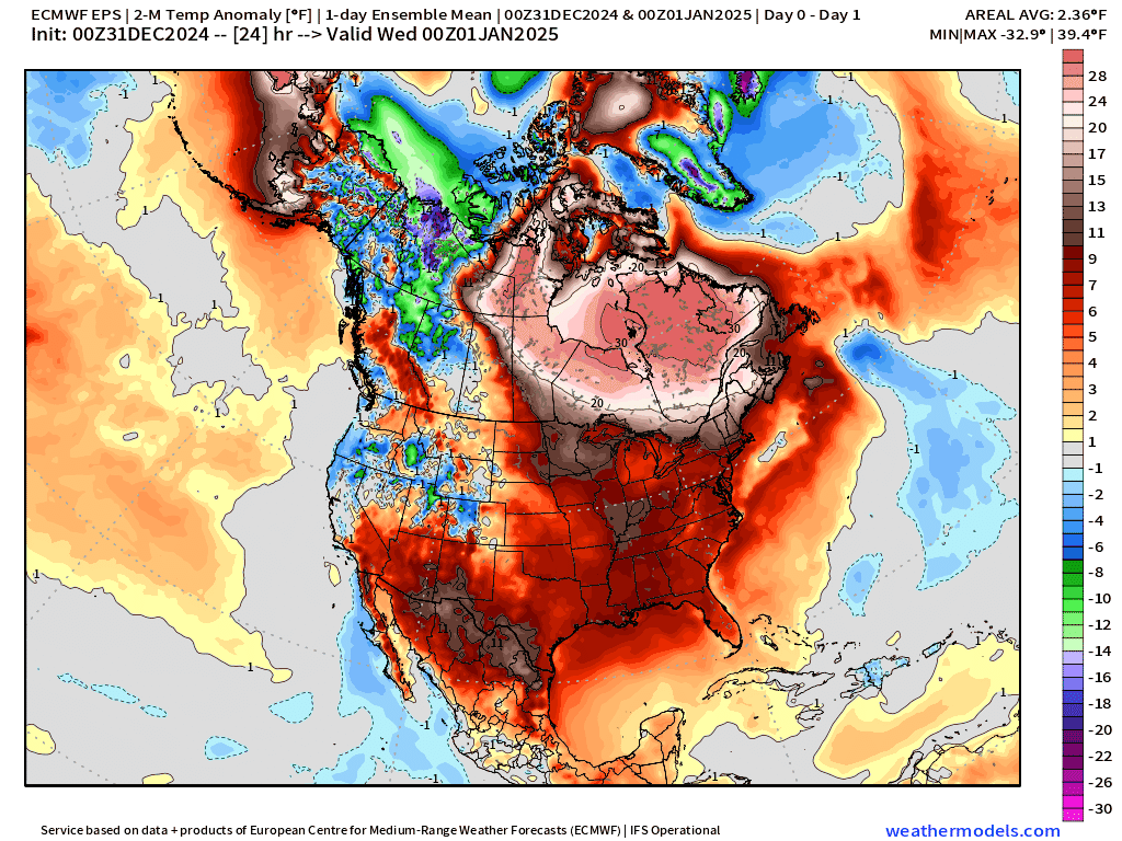
A Western Canada cold pool forms beneath strong high pressure over the next week, and breaks off into the Lower 48, but not entirely and all at once.
— An initial cold wave arrives this weekend.
— “Main Event” polar vortex plunge in the 10-12 day range more typical of previous Arctic blasts. However, the cold air available in the Arctic is not as substantial as historical “polar vortex” outbreaks.
Still remaining uncertainty: it’s clear from all of the model guidance that an extended 7-10 days period of much below average temperatures will affect mainly east of the Rockies. However, we cannot pinpoint the intensity and southern extent of the Canadian Arctic cold pool into the Lower 48 Southeast. Similarly, at the margin of the cold pool and warmer subtropical air masses, there is the potential for winter storm development. The variety of winter storm tracks, relation to warm/cold air, and time of day could mean all the difference between heavy snowfall in your location vs. dry weather. So, we can only make probabilistic forecasts after Day 7 — into Week 2 — to predict snowfall from blizzards.
Cut-off trough may be increasing Winter Weather threat to Texas, not seen in the ensemble means but in the deterministic guidance.

Winter Storm Next Monday
Most recent 8-day guidance from ECMWF HRES 00z shows the development of a powerful storm system over Oklahoma that tracks quickly east through Ohio River Valley then off the Mid-Atlantic coast.
Heavy snowfall along with sleet/freezing rain increasing threat.

Keep reading with a 7-day free trial
Subscribe to Weather Trader to keep reading this post and get 7 days of free access to the full post archives.