


December 31, 2023 New Years Eve
Winter storm watching with A.I. models
All of a sudden, the weather pattern has shifted into a very stormy 2 weeks ahead with several opportunities for major winter storms and/or Nor’easters. There is finally enough cold air available over the Lower 48 to combine with an energetic and moist subtropical jet to power respectable cyclogenesis.
The GraphCast-ECMWF [experimental/non-commercial] A.I. model shows 2 systems in sequence tracking from the Southeast into New England with epic levels of precipitation. And, I guarantee you this time, much of it will be snow in places largely devoid of winter so far.

Conventional physics based weather models are also on board with Nor’easter madness including ECMWF 12z this afternoon showing an absolutely wipeout snowfall map through 10-days across the Lower 48.

Of course, we use the ensembles to provide estimates of uncertainty. Using the mean/median from EPS 12z, you can see the snowfall from the HRES over Kansas into the Great Lakes is on the more extreme side of the solution envelope — in other words, less likely. However, the Northeast is higher certainty, which makes sense with colder air available.


And, a final piece of the puzzle is to calculate the probability of at least 6-inches of snowfall. I figure that’s a respectable value to indicate a major winter storm event. Yellow to red in New England is > 65%, so that’s a very good bet. Thankfully, only tiny chances here in Atlanta.
Zooming in and extending out to 15-days for at least 6” of snowfall — the probabilities are in the 25-50% range along an axis from NYC to Boston. Over the coming days, we will watch how this probability trends. I’d surmise it goes higher as more ensembles come on board with colder, more snowy solutions.

Monday High Temperatures | January 1, 2024

2024 starts out with rather mild temperatures in the Great Lakes and Midwest with 30s where it could be 0°F.
50°F in Atlanta could be warmer, however. Still in the low 70s in South Florida with about 10 million Americans seeing at least 70°F.
Temperature Outlook Next 2 Weeks
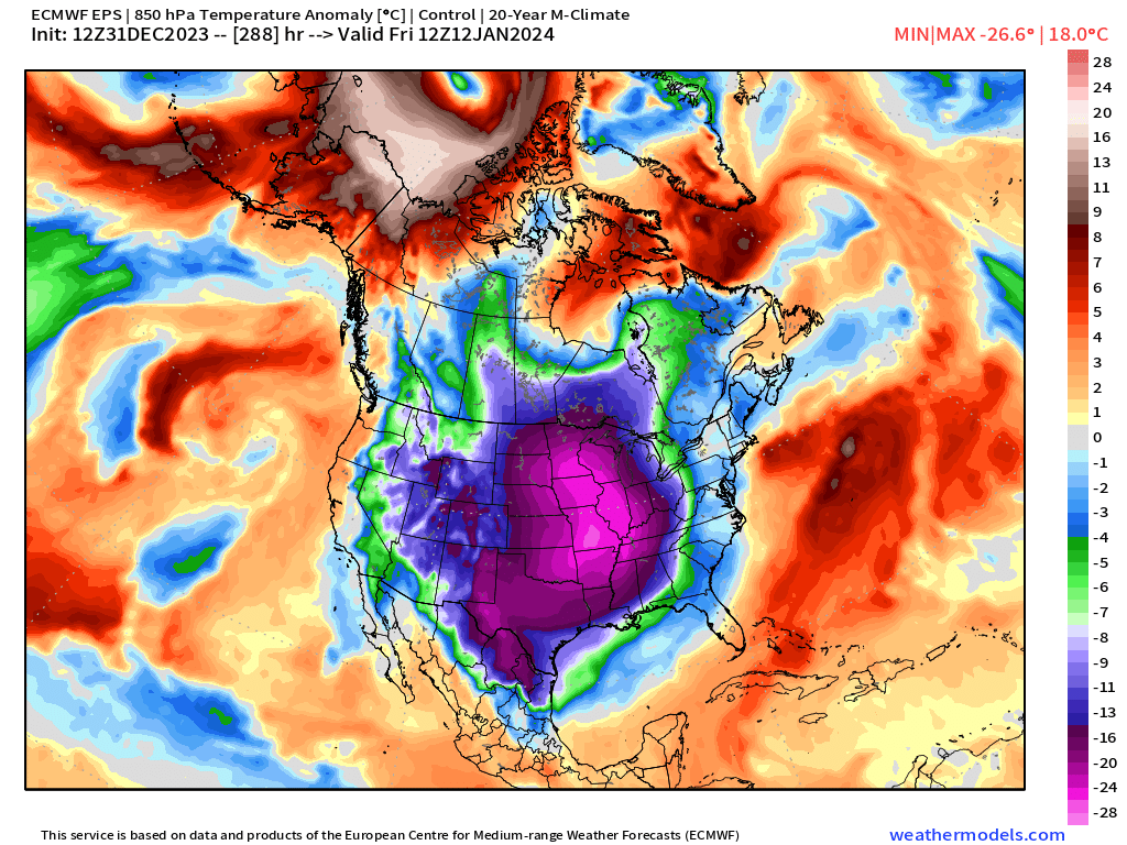
Say goodbye to the warmth across Canada in a week. By the 2nd week of January 2024, the entire Lower 48 sees near or below average temperatures with the coldest relative to normal in the lee of the Rockies. There is uncertainty about the intensity of the Arctic blast coming next week.
The EPS 12z control is full-on January 2014 “Polar Vortex” blockbuster extreme cold, but this is not the most likely solution. This would entail low temperature of -16°F in Chicago and 12°F in Atlanta. Note, this map is 850 hPa temperature anomaly with the “Barney purple” doing the honors of highlighting the Arctic blast.
Week 1: December 31, 2023 - January 7, 2024 [EPS Mean 12z]

Week 2: January 7, 2024 - January 14, 2024 [EPS Mean 12z]

7 Day Precipitation Outlook
NOAA WPC 7-day Total Precipitation including rain and snow together. The Gulf Coast states from Texas to Florida are in bonus land for rainfall amounts! A very wet pattern lies ahead with subtropical moisture feeding powerful winter storms.

2024 Global Tropics
Ghost town: The lack of strong low-latitude tropical cyclones is certainly odd for a burgeoning El Niño.
All maps are probably from weathermodels.com (please subscribe there for affordable, professional, and beautiful weather maps created by yours truly).
Thank you to my paying and freemium subscribers!
Your support pays for my Linux servers and product development including (coming soon) weathertrader.com. It also provides motivation to work harder.
Also, it allows me to provide (usually) interesting and valuable commentary on scientific topics on X. Feel free to say hello and follow on X/Twitter (@RyanMaue)
Old News:
This newsletter will rebrand in 2024 as part of roll out of [WT] https://weathertrader.com