


December 27, 2024 Friday Winter Weather
Much colder into January across Eastern US with major pattern change

Special Holiday Offer to Subscribe or Upgrade to Annual plan for 20% off. Your support is important for research, development, and growth of this platform into 2025.
Friday Morning Update: Good morning!
7:45 AM ET Temperatures across the Lower 48

Coldest temperatures by far in New England with some areas below 0°F. The nearly nationwide warm-up is missing much of the Northeast. Mild in the 40s into Chicago and Milwaukee and even 50s into Indiana.

Temperature Anomaly | 7:45 AM ET

Overall the Lower 48 is a whopping +10.3°F (above normal) … with large area of 20°F to 25°F above normal across the central U.S. from Louisiana to the Canadian border. Astounding temperature anomaly +40°F in Manitoba and Ontario = above freezing — it’s very cold normally, so even large positive anomalies do not mean shorts and t-shirt!
Friday High Temperatures

Lower 48 average high temperature is almost 51°F. Still about 3-million Americans that won’t get above freezing, but that’s less than 1% of the population. 47 Million at/above 70°F across the South, and some 80s in Florida and Texas.
Weather Headlines for Friday
Pacific Northwest storm systems and atmospheric rivers into Saturday.
Ongoing storm system with plenty of Gulf of Mexico moisture heading through the Gulf Coast states = heavy rain, rumble of thunder. The low pressure moves into the Great Lakes with rainfall. Later this weekend, yet another storm forms across Texas on a similar track with much more heavy rainfall for the South.

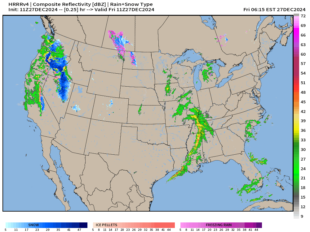
HRRR Simulated Radar Next 18-hours through Midnight 
Major pattern change to begin January 2025! Temperature anomaly by January 2-3 will significantly turn negative (next Thursday) with the first wave of colder Canadian continental air on the backside of the “wasted Nor’easter”. However, models trending colder into Jan 8-10 with a “main event” polar vortex “Arctic blast” that aligns the large-scale circulation from the troposphere into the stratosphere (usually anchored over Hudson Bay or northern Arctic Canada).
Temperature Anomaly next 15-days


ECMWF 00z precipitation type and MSLP next 7-days
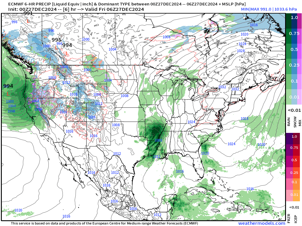
Colder air arrives behind a storm system that tracks across the Rockies into the Ohio Valley, and then deepens over Canada next week from Tuesday-Thursday. I mention it as a “wasted Nor’easter” because it could have been a blockbuster blizzard on a slightly eastward track over the waters of the Atlantic. However, it will begin the process of flipping the overall upper-level pattern for Northwest flow out of Alaska/Arctic into the Lower 48 by end of next week.
NWS | Total Precipitation Next 48-hours

Large area of 2-inches+ rainfall from Louisiana into the Southeast including Atlanta and the Carolinas, and into the Mid-Atlantic.
2-day totals of precipitation in the 2” to 6” range across northern California into the Cascades where higher elevations will see enormous snowfall.
NWS | Total Snowfall Next 72-hours


While the storm systems are relatively warm with Pacific moisture from subtropical origin atmospheric rivers, the air mass is cold enough at elevation to see many feet of snowfall.
Total Precipitation next 7-Days | NOAA WPC

Very wet pattern for Eastern U.S. for late December. Boatloads for Pacific Northwest.
15-Days Ensemble Median Snowfall
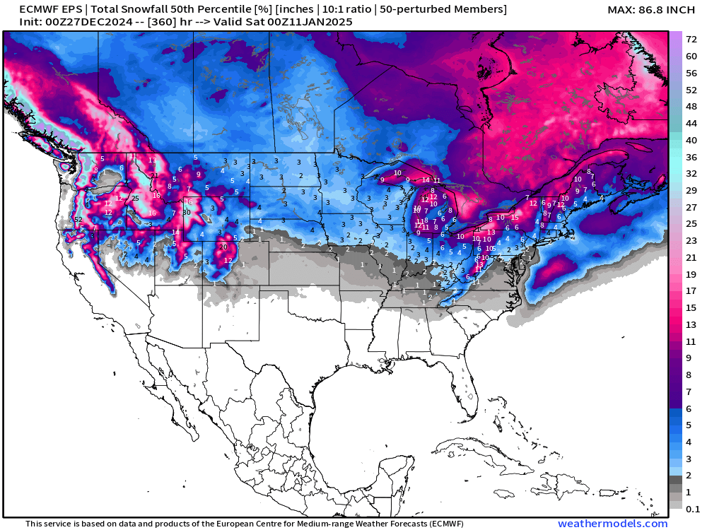
Interesting to see 0.1” of snowfall showing up in North Georgia on the “median” accumulation map through 15-days. Significant Lake Effect + western Mountain snowpack building!
*** What if ** Maximum Ensemble Snowfall Next 15-days
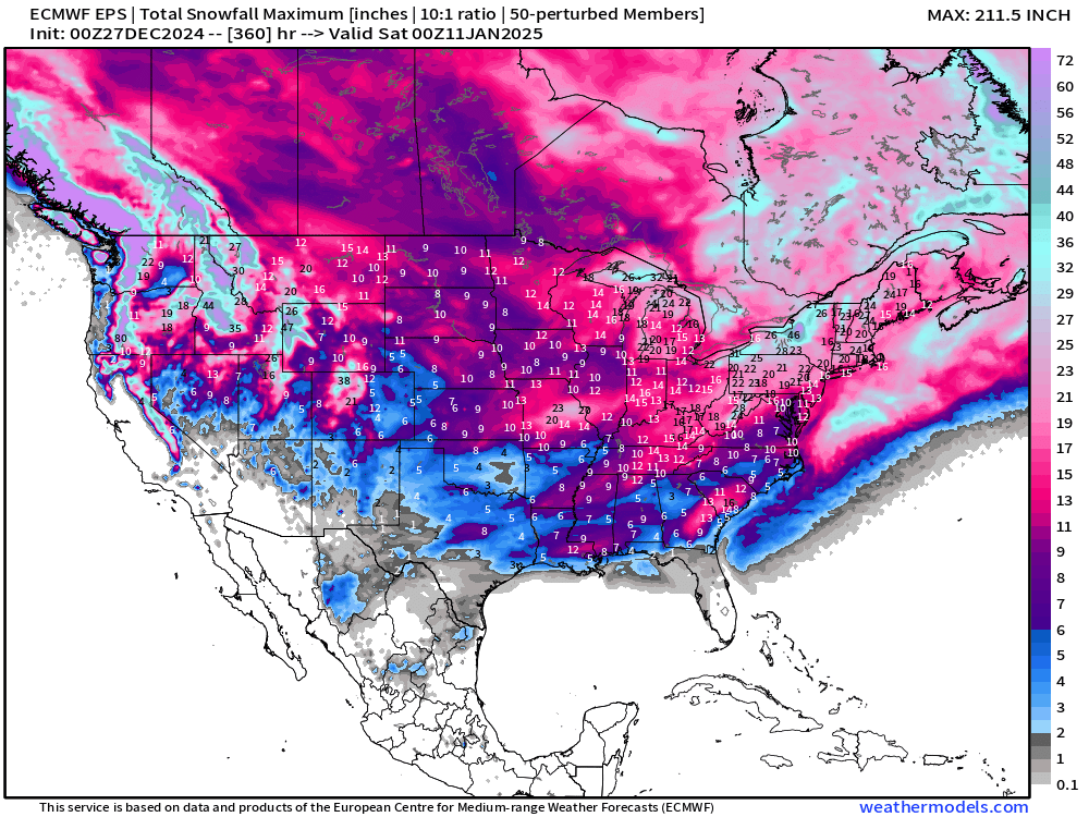
What’s the worst case scenario out of the ensembles for snowfall? Obviously this can’t happen everywhere at once — think of it as the top 2% or highest snowfall result at each grid point from the EPS 00z. This can be an underestimate, too, because an individual ensemble might not capture successive events that may occur. This **what-if** into January 11th is significantly more aggressive than what we would expect for climatology. No doubt the upcoming Eastern U.S. pattern is favorable for Winter Storms like early December, but the main question will be the availability of moisture to fuel a “bomb cyclone” or Nor’easter.
Probability of 0.1”+ Snowfall Next 15-days
Any snow over the next 15-days?

Small chances into Florida — even 2% in Orlando. Better than 50/50 in Atlanta and the Carolinas.

ECMWF EPS 00z | 5-Day Chunk Temperature Anomaly
Days 1-5: December 27 - December 31

Days 6-10: January 1 - January 5

Very cold over Western Canada — poised to dump into the Lower 48 for 2nd week of January.
Days 11-15: January 6 - January 10

Very significant cold anomaly across Eastern U.S. with [relative] warmth out west.
Snowfall Analysis | Season to Date October 1, 2024 — today

Maps sourced from weathermodels.com designed and innovated by yours truly! Please subscribe there for real-time access to the newest maps, charts from all of the weather models including ECMWF.