


December 23, 2024 Monday Winter Weather
Clipper system in Great Lakes and Northeast into Tuesday

Special Holiday Offer to Subscribe or Upgrade to Annual plan for 20% off. Your support is important for research, development, and growth of this platform into 2025.
Quick note: ECMWF has a new A.I. ensemble system called AIFS-CRPS with impressive skill that exceeds the current physics based IFS (EPS) system. Soon, data will be provided from the 0.25° resolution model — and hopefully the weights to reproduce the forecasts, and generate our own. This will be a game changer. ECMWF has been running an experimental, low-resolution (~1.0°) AIFS ensemble, and even that system has shown remarkable skill. The new AIFS-CRPS will be a step upgrade.
AIFS-CRPS [pre-print]
For the usefulness of a weather forecast it is important to account for forecast uncertainties. Ensemble forecasts are run to estimate the probability density of the atmospheric state at a future time [Lewis, 2005, Leutbecher and Palmer, 2008]. In physics-based numerical weather prediction (NWP), this is achieved via running the forecast model from a range of perturbed initial conditions and by introducing stochastic perturbations into the forecast model itself. The aim is to generate a well calibrated ensemble. This means that on average, the ensemble standard deviation needs to match the root-mean square error of the ensemble mean (e.g., Fortin et al. [2014]), and the predicted probability of an event should accurately reflect the observed probability of it occurring.
Good morning! Monday starting off very cold across the Mid-Atlantic and Northeast.
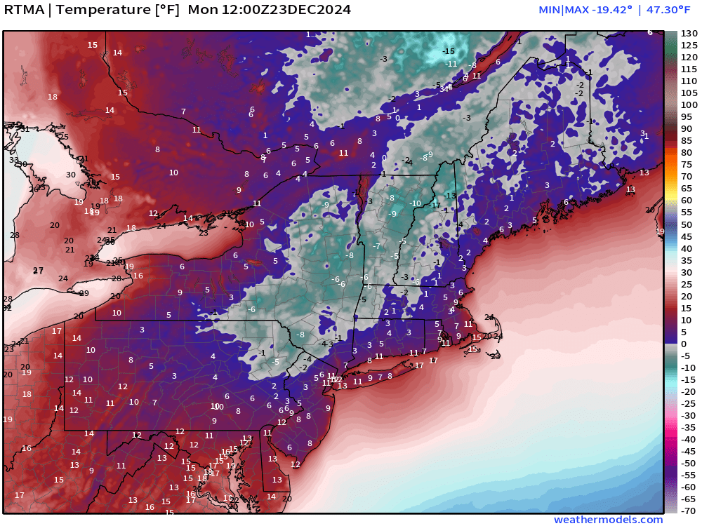
Temperatures well below zero in the interior of New York and New England.
This is more than 30°F below normal for December 23.

Calm conditions under strong high pressure (1036 mb) allows significant radiational cooling especially over snow-covered ground. Temperatures crashed and will only recover into the 20s later on Monday.

Weather on Monday

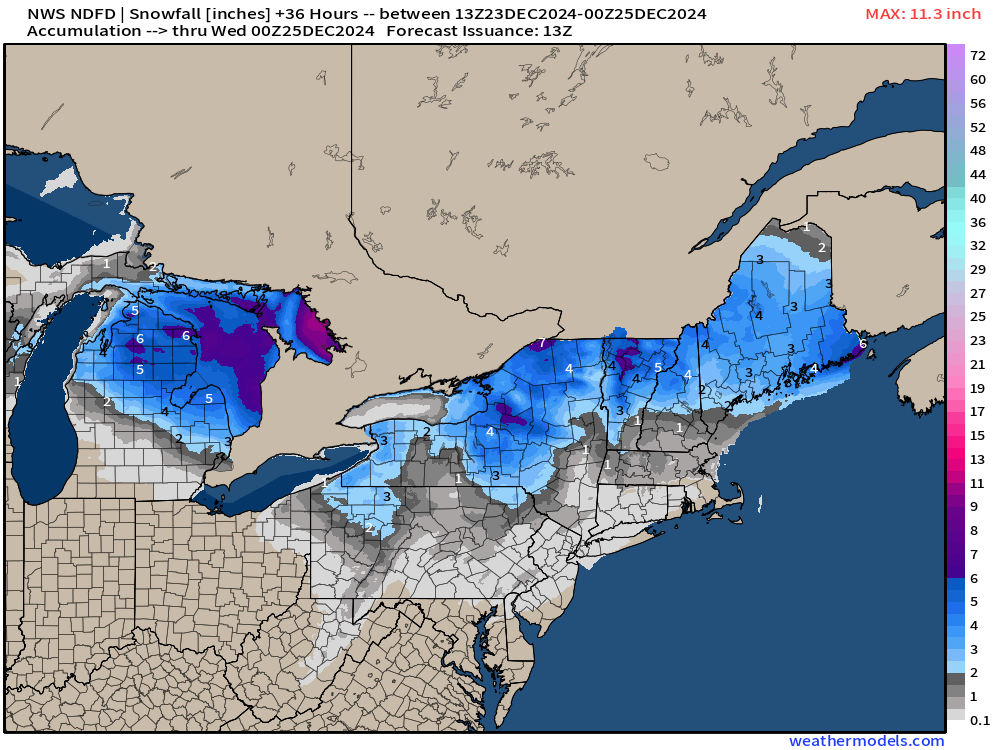
Yet another Clipper system across the Great Lakes into the Northeast on Tuesday.
Weather through Midnight | HRRR simulated radar
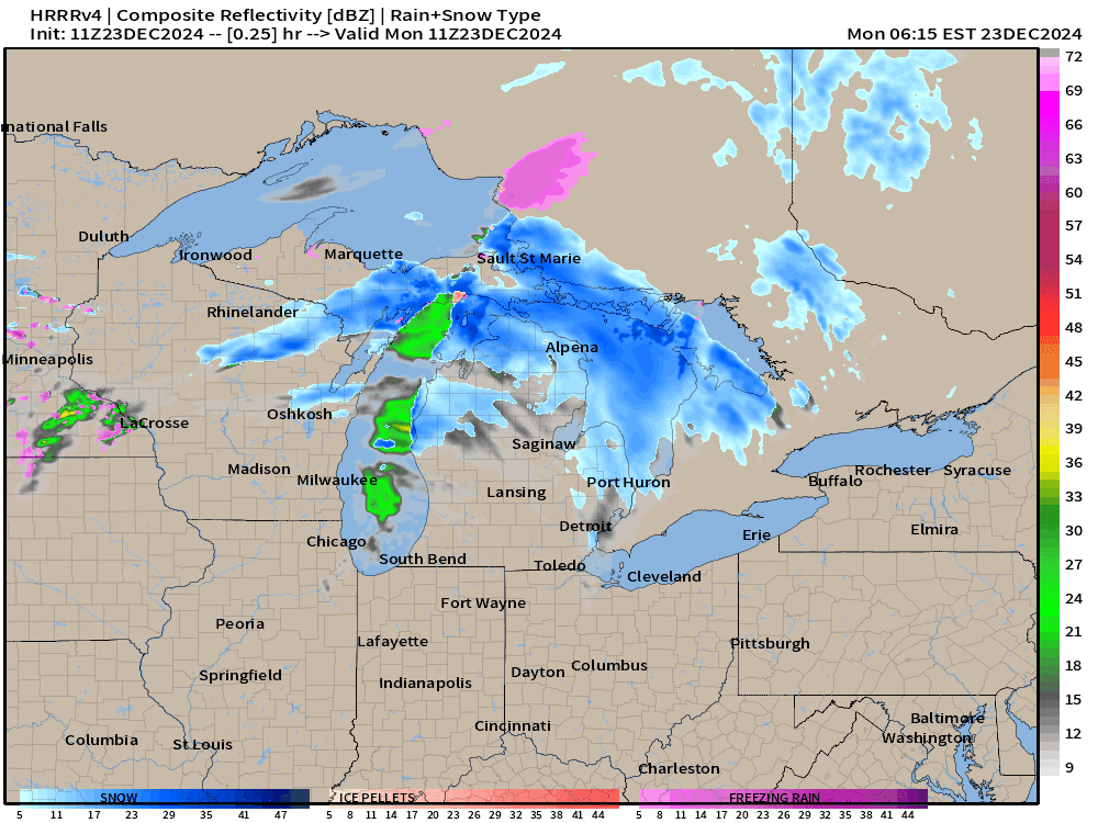
NWS expects 3-6” of snow across Michigan on a diagonal line from Manistee to Port Huron. However, as the Clipper moves east overnight into New England, the snowfall will weaken to lighter accumulations — but YES we will still see snowfall Tuesday morning in New York City for sunrise. It will be beautiful for Christmas Eve!
At about 10 AM, HRRR has a light band of snowfall from Boston to NYC to Philadelphia! An inch or so in an hour of moderate snowfall should be expected.
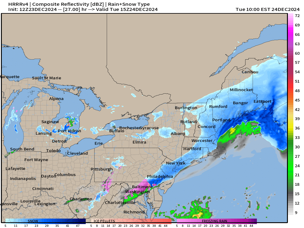
Will this Clipper system outperform like last week? HRRR model snowfall does have > 1” across NYC.

ECMWF Precipitation Type and MSLP Next 6-days
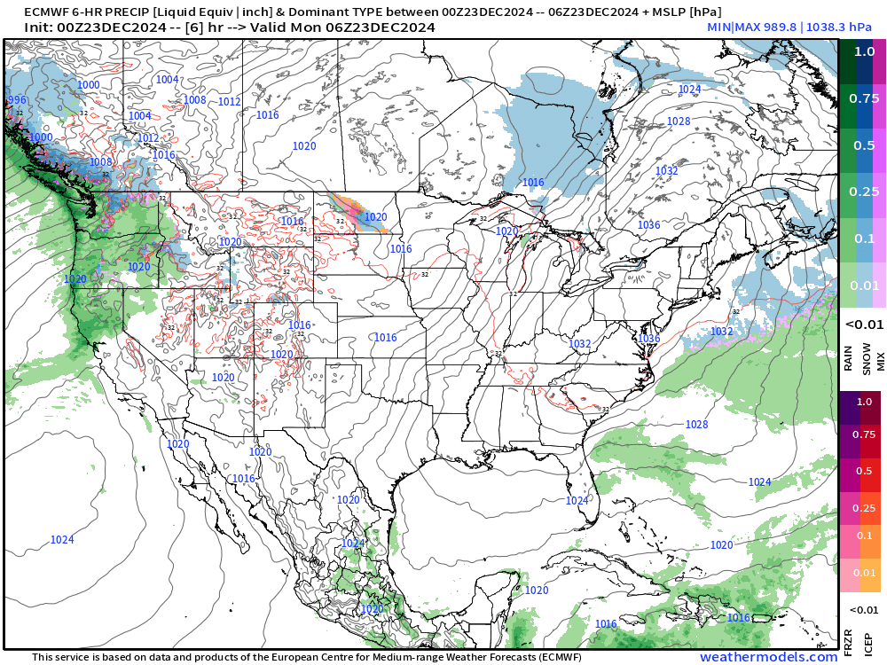
Gulf of Mexico moisture streams northward up the Mississippi River valley over the next several days leading to heavy rainfall accumulations — maybe upwards of 4-6”.
The West Coast continues to be hammered by atmospheric rivers.
Much warmer air will sweep across the Midwest and Great Lakes after Christmas, so any precipitation would be rain.
Looking ahead into 2025 for the Pattern Flip


Quite an enticing pattern for winter storm wish-casters across the Eastern U.S. with a large trough sitting over a large area in the ensemble mean —> first week of January.
Much colder Canadian Arctic air will finally replace the much above average warmth across western Canada and the Lower 48 into January 1-2, 2025.
So, we have 8-days or so of above average warmth to end 2024.

Monday High Temperatures

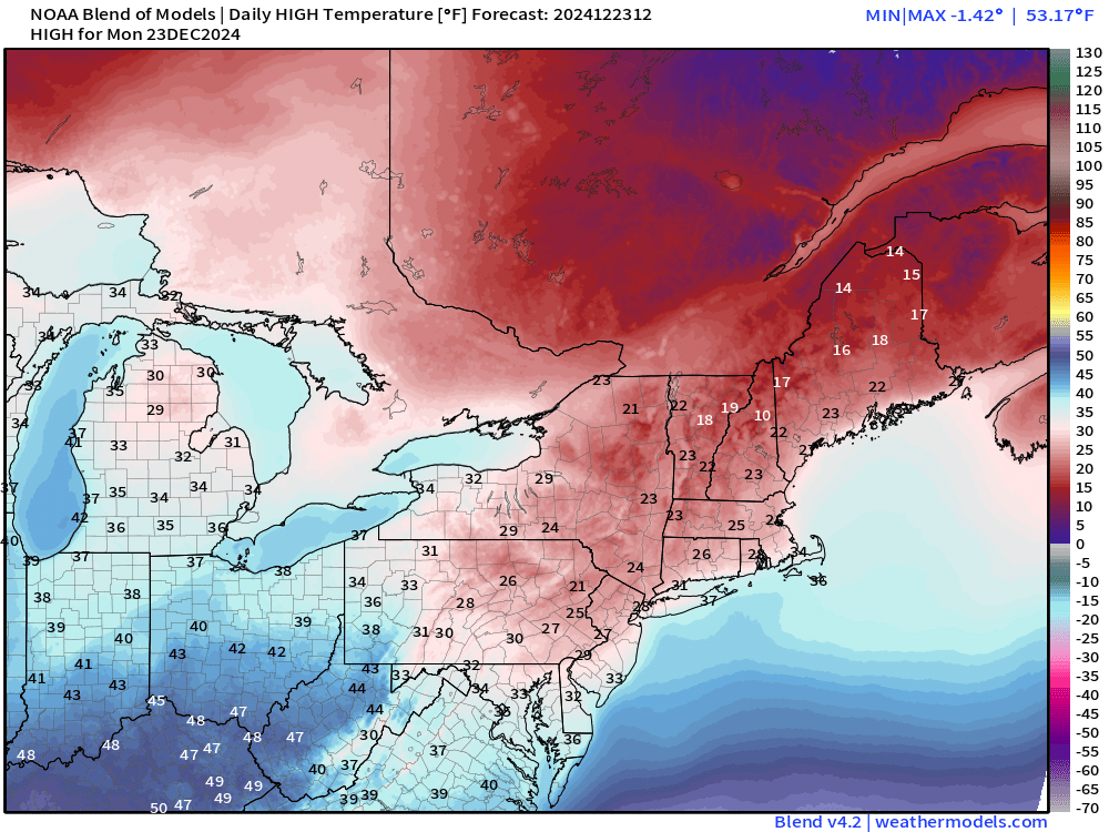
More than 57 million will fail to get above freezing especially across the Northeast on Monday. Widespread 50s across the Rocky Mountain west!
Tuesday Morning Temperatures | Christmas Eve

Still very cold across New England in the teens! Temperatures will finally warm up during the day to above freezing, barely!
Tuesday High Temperatures

Wednesday High Temperatures | Christmas Day

Seasonably chilly in the low-30s across the Great Lakes and Northeast for Christmas Day. In the upper-50s to lower 60s from Nashville, Atlanta, down to Macon.
8:30 AM ET Temperatures across the Lower 48

More than 186 million now below freezing this morning.
Temperature Anomaly | 8:30 AM ET

Overall the Lower 48 is still 5.4°F (above normal) with warmth west of the Mississippi crushing the extreme cold centered upon NYC.
Total Precipitation next 7-Days | NOAA WPC
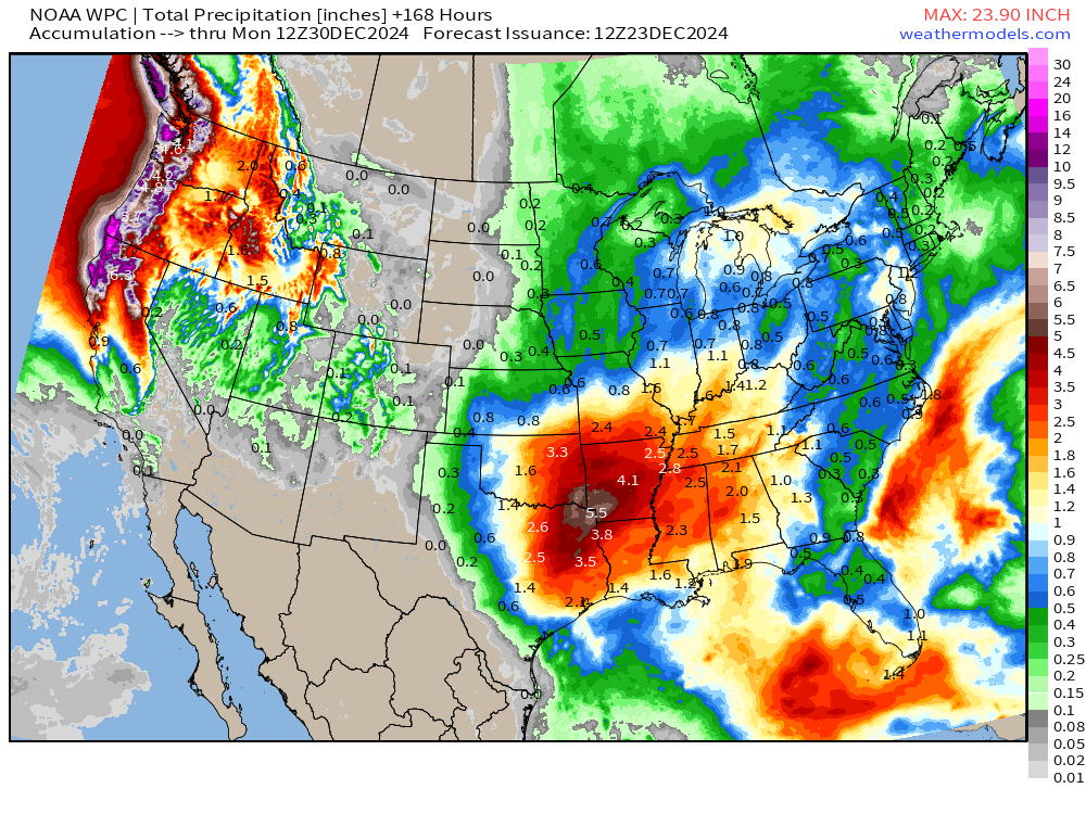
WPC now showing area of 4-6” centered over Texarkana and large area of 2-inches to 4-inches centered on Little Rock.

NWS WPC with large areas of 12-18” of rainfall along the NorCal coast up into Washington. And, that could be conservative!
10-day Ensemble Median Snowfall

Sadly, not expecting any major snow threats after the Clipper exits into the Atlantic on Tuesday. The Western U.S. does cool down so more widespread snowfall at lower elevations. Regardless, the atmospheric rivers will dump 8-feet or more in the Cascades.
Probability of 3”+ Snowfall Next 10-days

Looking for a major storm with 3” of snowfall threshold — and nothing else on the radar. The huge hole in Canada exemplifies the extreme warmth in Alberta and Saskatchewan — relative to normal — of course. It’s still not shorts and t-shirt weather!
ECMWF EPS 00z | 5-Day Chunk Temperature Anomaly
Days 1-5: December 23 - December 27
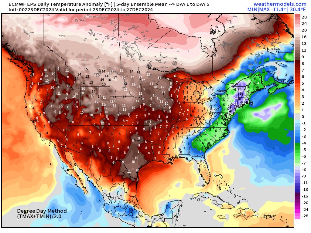
The cold overnight lows across the Northeast = strong 5-day average cold signal.
Days 6-10: December 28 - January 1
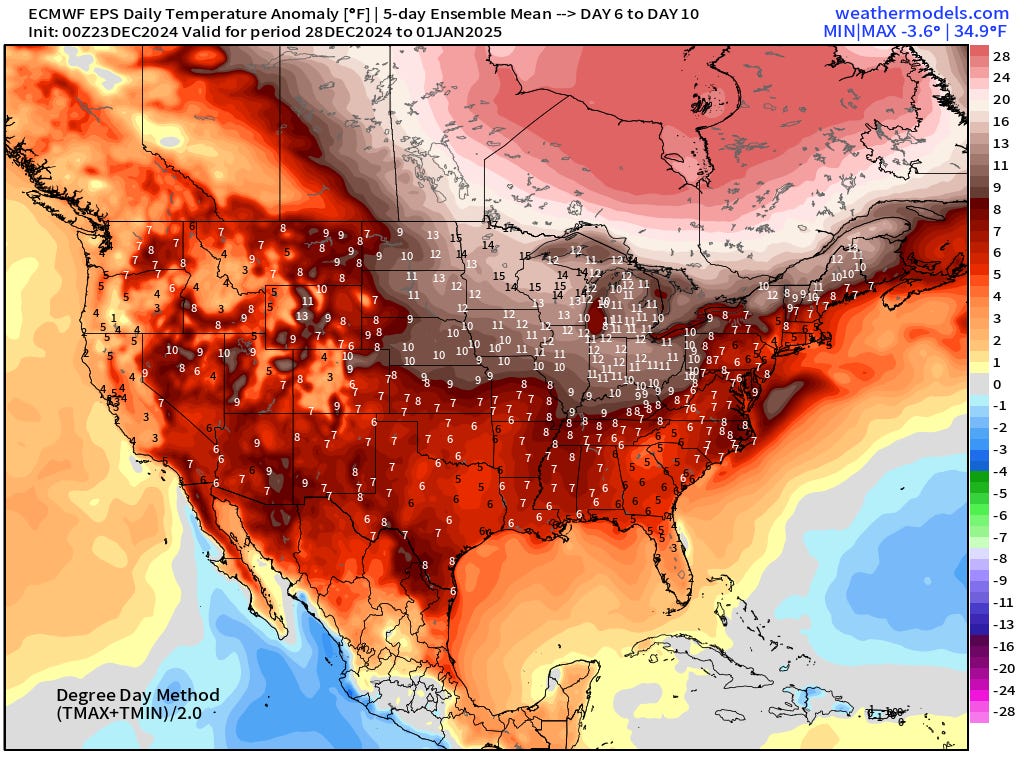
Coast to coast well-above normal warmth with > 30°F anomaly over Canada.
Days 11-15: January 2 - January 6

The coldest anomaly in the Day 11-15 period centered on Florida!
Snowfall Analysis | Season to Date October 1, 2024 — today

Snowfall Month-to-Date | December 2024
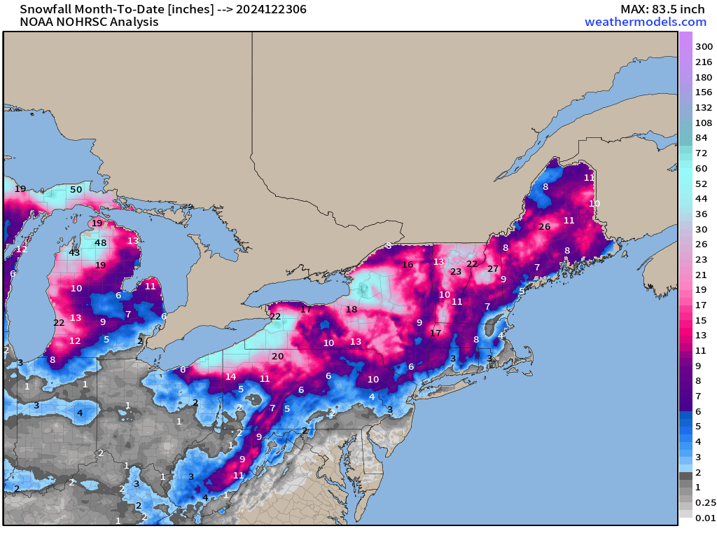

Not too bad for December! We’ll look back and see these maps — and say, wow, that was a snowy month in 2024.
Maps sourced from weathermodels.com designed and innovated by yours truly! Please subscribe there for real-time access to the newest maps, charts from all of the weather models including ECMWF.