


December 15, 2023 Weekend Storm
Powerful Nor'easter taking shape this weekend
An impressive and dynamic storm system will form in the Gulf of Mexico and cross Florida into the GA/SC into Sunday, continuing its trek up the east coast inland into Mon/Tue. The major impacts will be heavy rain of 2-4” widespread from Florida to Maine with gusty winds of 40-60 mph — highest along the immediate coast — pushing water onshore contributing to coastal flooding and erosion. Thunderstorms could be severe with embedded weak tornadoes and winds in excess of 60-mph. It will be functionally a strong tropical storm from Florida to Maine. Sadly for winter weather lovers, there will be limited chances of snow except in the higher elevations of PA, NY and New England.
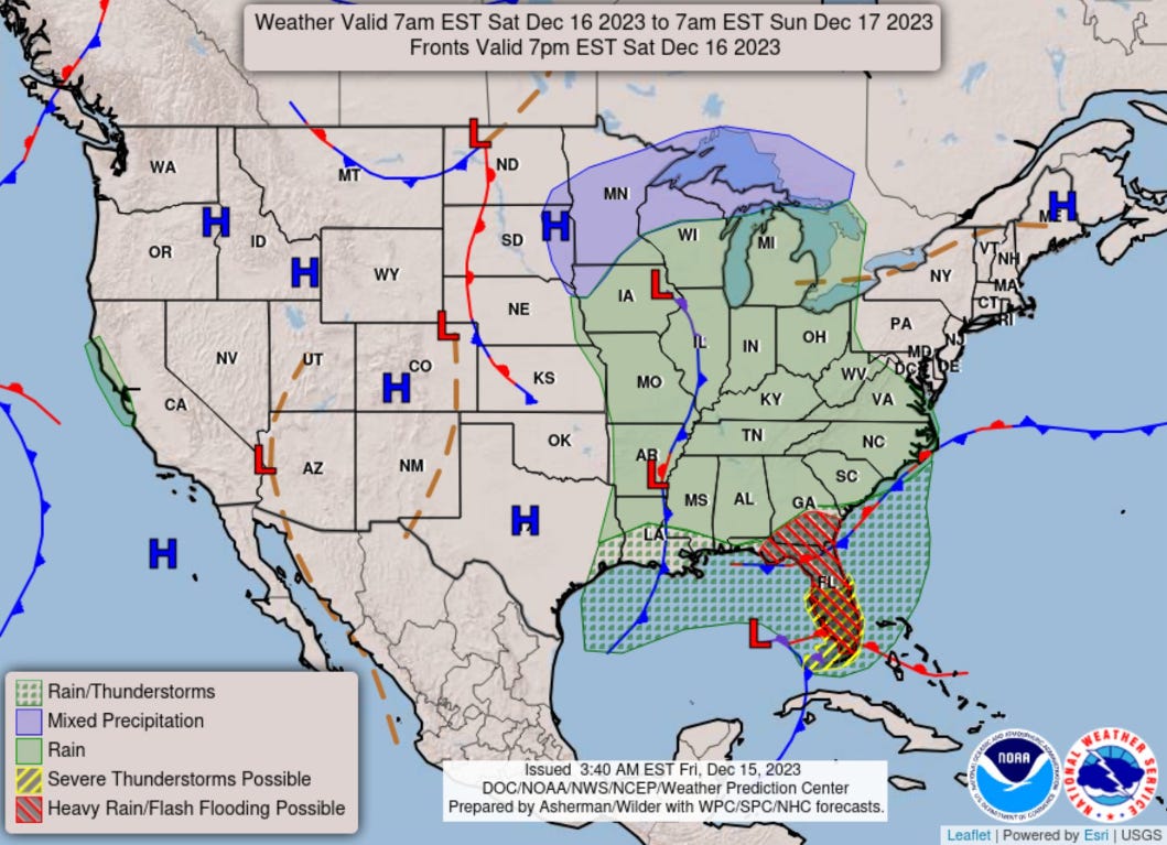
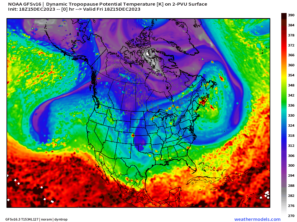
The central pressure should reach into the 980s or maybe lower as the center of the low taps into the warm waters of the Gulf Stream (diabatic energy + latent heat flux) with a significant moisture feed — like an atmospheric river. Behind the powerful storm, it turns out a lobe of the tropospheric polar vortex will be pulled into the Southeast U.S. providing a quick shot of Arctic air into Tuesday.

The polar vortex in the troposphere is outlined by the purple or colder colors on the tropopause. It turns out that later on Mon/Tues, a cyclonic PV anomaly rapidly advects SE out of Canada into the mid-Atlantic behind the mature coastal low and mid-level trough. Everything is fantastic in terms of the dynamics here — pressure fall, plenty of moisture, but the cold air is not coincident along the coast, so it’s all rain, and a lot of it. The Canadian Arctic air plunging into the Great Lakes and eastern Lower 48 is really pathetic with 850 mb temperatures barely at -10°C.
That is more akin to mid-October than mid-December.

Gusty winds across the Southeast, mid-Atlantic, and Northeast will top 30-40 mph from Florida to Maine.

NYC and Boston again under threat for 40-50 mph wind gusts with significantly higher gusts just offshore including hurricane force winds to generate huge waves and swell.

Saturday High Temperatures
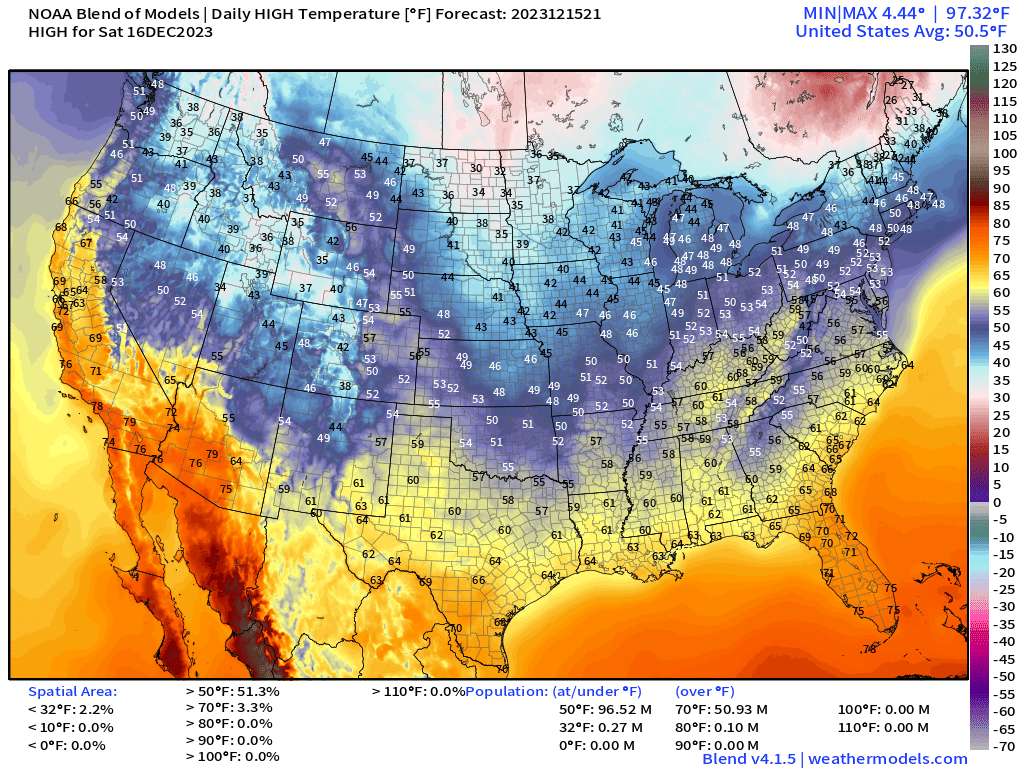
Nationwide average high temperature for Saturday is almost 51°F. Again, wow for mid-December and looks like a broken record until 2024. 40s and 50s into the Great Lakes, Ohio Valley and southern New England — looks like El Niño. Can’t scare up any snowflakes with temperatures 15-20°F above freezing.
Sunday High Temperatures

Similar high temperatures for Sunday, but definitely clouds and rain providing a weird mid-December day in the Southeast. Complete washout for Florida.
Temperature Outlook Next 2 Weeks
The very cold air in Siberia will spill into China over the next several days. Canada remains very warm for the next 2-weeks or longer especially with the strong zonal Pacific jet on the way.
Week 1: December 15 - December 22 [EPS Mean 12z]

Eurasia and Canada pushing 25°-30°F above normal for 7-day averages to end 2023. Greenland and the North Pacific will become very cold to balance out the warmth but won’t be enough. We can expect record warm global temperatures to end 2023.
Week 2: December 22 - 29 [EPS Mean 12z]

15-day Snowfall ECMWF EPS [median] and Probability of 3-inch of snowfall


I keep looking out 2-weeks still do not see a sustained signal for a winter storm or pattern shift to typical early winter snowfall. The good news is that the moisture firehose directed at the Pacific coast will find enough cold air especially at higher elevations to help out the ski resorts.
7-Day Precipitation Outlook


The USA will see 32 Trillion gallons of precipitation (liquid equivalent) over the next 7-days, which is a number we’d expect to see in middle summer! California is the biggest winner at 6.0 Trillion with Florida at 3.1 Trillion gallons according to the most recent 00Z NWS WPC forecasts grids. Very widespread area of 2-4” along both coasts.
2023-2024 Global Tropics
Invest 91W in the Western Pacific is being watched by JTWC for weak tropical storm development east of the Philippines.
Thank you to my paying subscribers! Your support pays for my Linux servers and product development, and soon A.I. weather forecasts once I figure out the license restrictions. We just got another new entrant into the A.I. model lineup from China called FuXi. Also, it allows me to provide unfiltered commentary on scientific topics on X. Feel free to say hello and follow on X/Twitter (@RyanMaue)