


December 12, 2024 Thursday Winter Weather
West Coast including California to see most active weather for next week

Thursday Headlines:
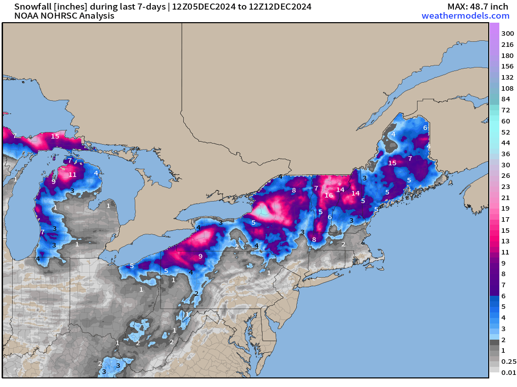
Lake Effect snowfall finally winds down across the Great Lakes, but still plenty more accumulation to come especially along Erie just south of Buffalo (more for Orchard Park on top of 3-feet already), and the Tug Hill Plateau (Watertown) maybe 2-feet more.

Active North Pacific storm track will see multiple powerful storms form over the ocean and be impactful to the West Coast of the U.S. Downstream of these storms, a ridge is formed over the Pacific Northwest into Canada that then control the ability of troughs to dig into the Great Lakes and across the Eastern U.S. in the 7-10 day range.
With all eyes on Christmas week for travel and hoping for a storm system that may provide some snow cover for Santa Claus, we have a lot of uncertainty in the model guidance in the extended range. No surprise there at all. I’ll outline the players for Day 7 across the Lower 48.

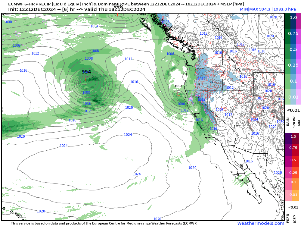
The North Pacific has multiple hurricane-force lows in the next 10-days typical of mid-December. Some even reach into the 930s mb central pressure. It is the development and tracks of these systems that trigger the downstream Rossby wave responses and the wave like patterns we see e.g. ridge/trough etc.
The initial conditions of numerical weather prediction models need to be as accurate as possible over the vast expanse of the Pacific Ocean to generate the best possible medium-range forecasts over North America in 5-7 days. While there is aircraft and some ship observations, the vast majority of information for the data assimilation into the weather models come from satellites.

Next 7-days Precipitation Type | ECMWF 12z
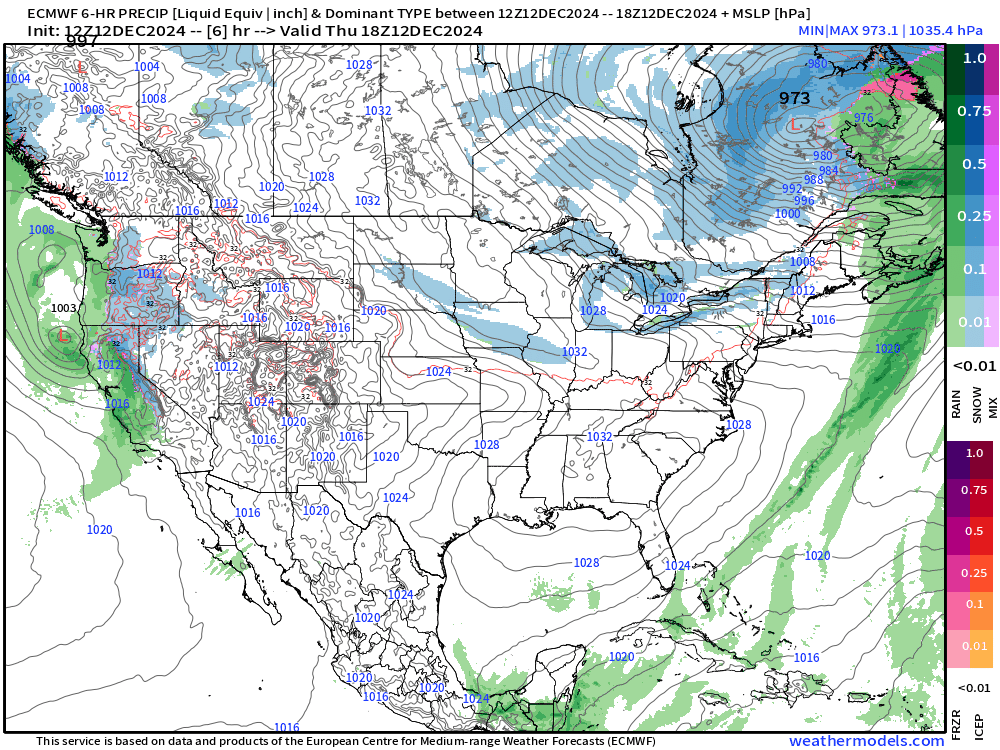
A powerful area of high pressure (anticyclone) builds over the Northeast with pressures in the 1040s mb.
Southerly flow in the central U.S. around the back side of that high pressure helps fuel a few storms systems, and the strongest late next week might produce significant snowfall (system snows) but still much uncertainty.
Not much uncertainty about the powerful atmospheric rivers and storm systems due for the West Coast this weekend, and then again early next week.
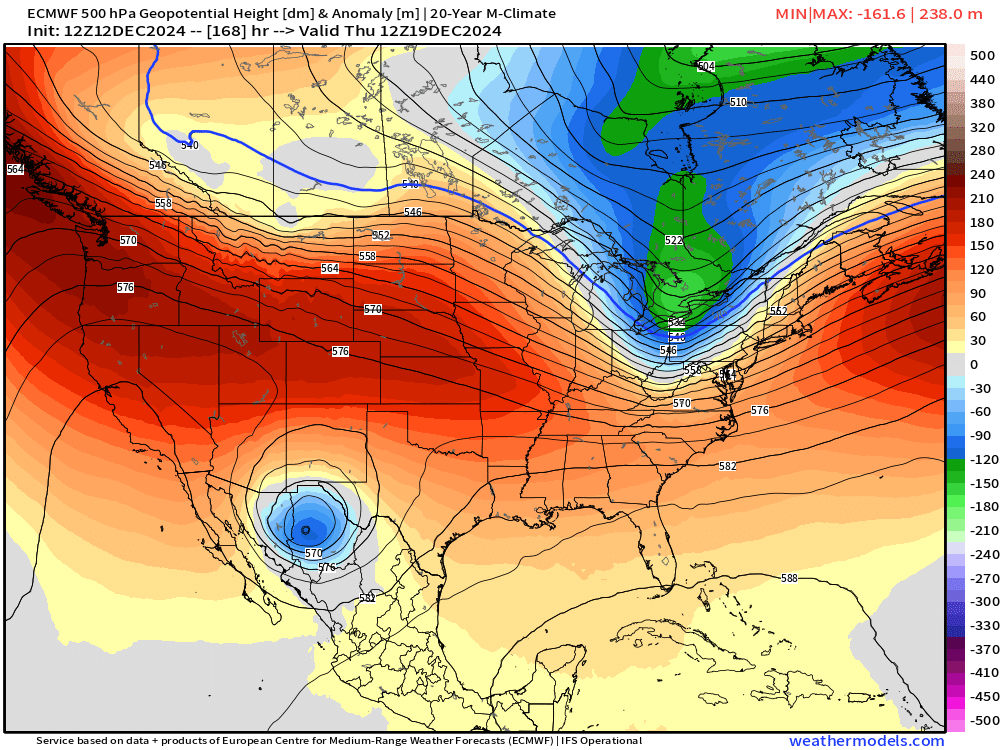
Day 7 Weather | Next Thursday December 19, 2024
I want to focus on next Thursday morning as the turning point into the following weekend. This is the precipitation type showing snowfall in West Texas and the freezing line extending into Little Rock and then through the Ohio Valley into the Northeast.

Note the little trough — not too impressive — but getting the job done with enough cold air to definitely provide heavy frozen precipitation on the back side of the Arctic front.
However, the little cut-off low sitting in northern Mexico is a key component of the following week forecast. This little guy is moving slowly to the east, and will try to phase or couple with the so-called “polar vortex” trough to the north.
You’ll see the result shortly … at Day 10 from the models (GFS, ECMWF, AIFS)
5:30 PM ET Temperatures across the Lower 48

Single digits from Minneapolis to Milwaukee this evening. Quite the frontal gradient through St. Louis into the Ohio Valley with comfortable / mild weather to the south.
Except for along the Great Lakes shorelines, the winds have really died down under strong high pressure, so wind chills aren’t as crippling as they could be with such cold.

Largely calm conditions over the Southeast with breezes in central and south Florida.
Temperature Anomaly | 5:30 PM ET
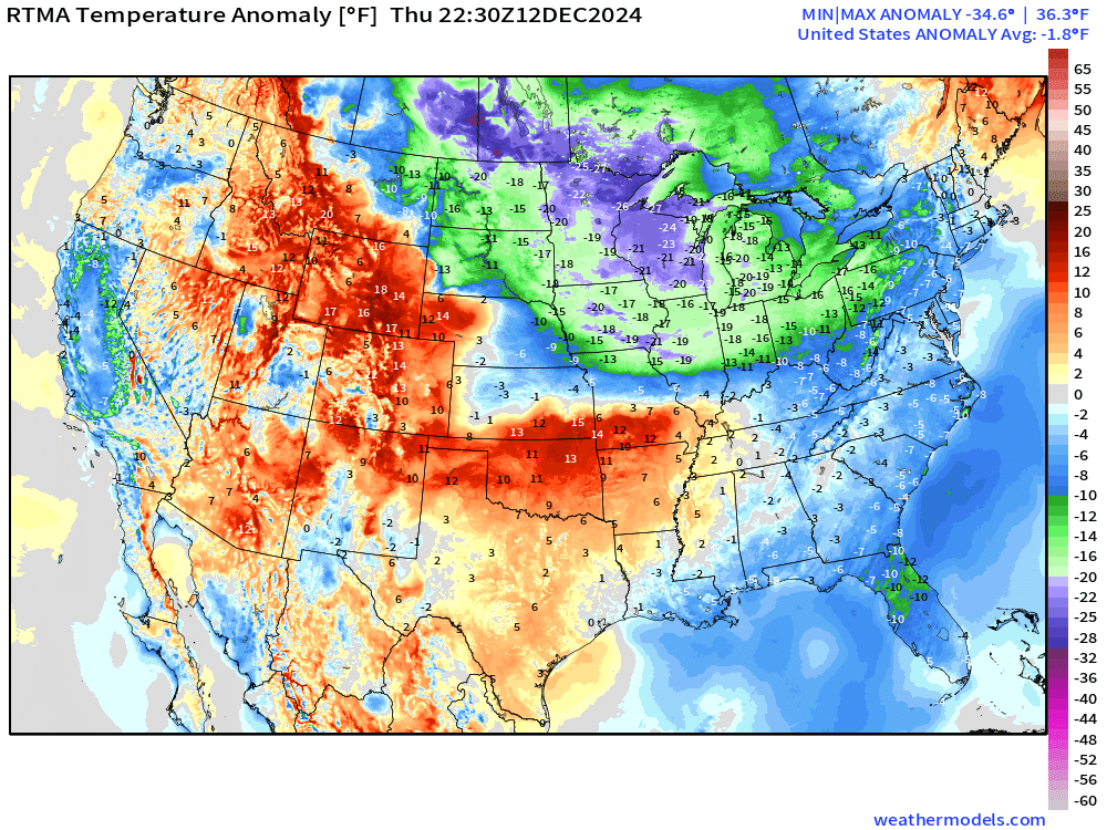
Overall the Lower 48 is -1.8°F (below normal) with with cold anomalies more than 20 below a typical mid-December early evening.
10-Day Upper Level Pattern | ECMWF 12z AIFS
Now back to the upper-level wave pattern. The story of the past few weeks has been repeated and strong ridging across the Western U.S. and into Canada. And, in 10-days, we are right back to that broken record.
So, we’re left with question of how intense, if at all, the tropospheric polar vortex (TPV) anchored firmly over the Hudson Bay can impinge or dig into the Great Lakes or further south.
AIFS (ECMWF’s artificial intelligence trained system) notable does NOT have the little impactful cut-off low in its forecasts at Day 7 over Mexico, but a small reflection that swings through into the Southeast. But at Day 10, there’s a height anomaly centered in the Mid-Atlantic.
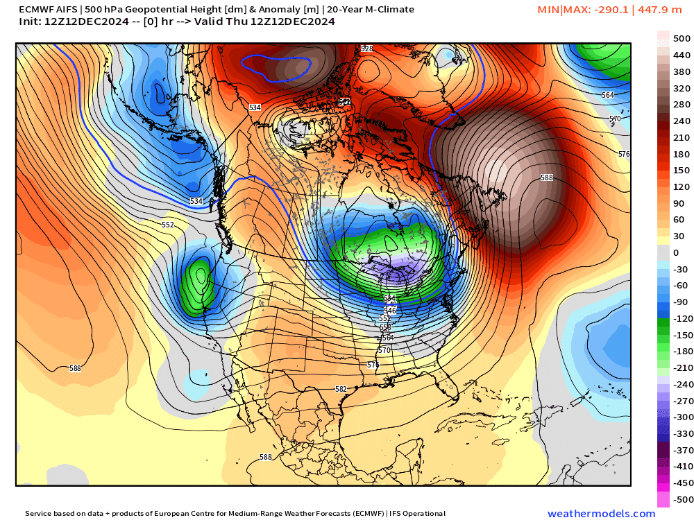
Now, at Day 9 from ECMWF HRES 12z, the little cut-off low has drifted east into the panhandle of Florida with a connection to a weak wave in the eastern Great Lakes. Humongous ridge with 540 dm heights stretching well into the Arctic ahead of a very powerful North Pacific ocean bomb cyclone.

And, the best for last from GFS 12z at Day 9, which blows up the trough significantly in the Southeast in a perfect configuration for a Miller Type A mid-Atlantic blizzard. GFS went crazy with like 6-feet of snow in New Jersey with the 12z forecast, but I’m not going to show that.

Over the next few days, we’ll watch how these upper-level features trend and evolve … and should know by Sunday if we’re going to load up on Arctic blast + snowfall across the Eastern U.S. for Christmas week, or just enjoy seasonable temperatures.
Low Temperatures on Friday

Coldest morning in a while — well below zero in Minneapolis. NWS has -3°F Warmer in Chicago around 7°F.
High Temperatures on Friday

Some moderation but not much across the Great Lakes only in the 20s at most. Maybe near/above freezing from NYC to Boston.
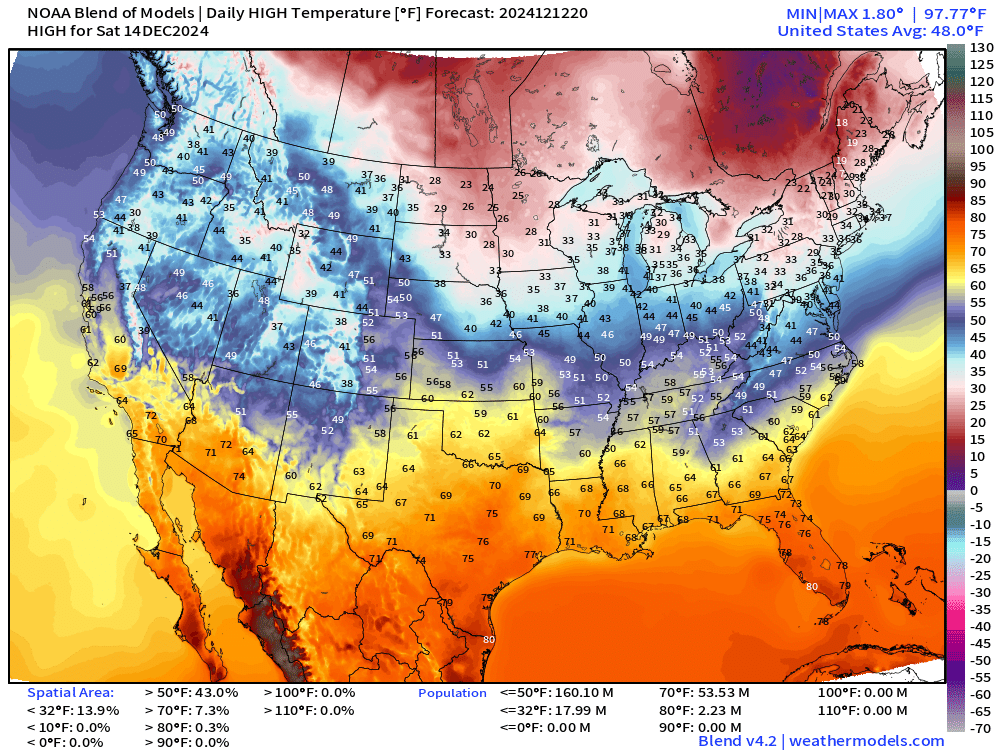
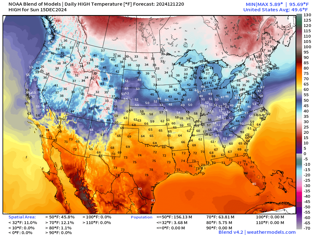
Look ahead to Weekend High Temperatures
Saturday: Warming trend to a thaw in Michigan and up to Green Bay in Wisconsin.
Warmer still on Sunday.
Snowfall Forecasts
15-day Ensemble Median Snowfall

California will benefit from the active North Pacific storm track with potential for hugely impactful atmospheric rivers dumping snow on the mountains.
However, the stars are not well aligned for a Nor’easter or a blizzard or major storm system … except something that bombs out in Canada like this current system.
Probability of 3”+ Snowfall Next 15-days

The potential for snow is quite low — but not zero from Texas into North Georgia. We’re looking at only 1-3 ensembles at most with a snowfall event — too tiny of a % to get excited about.
Total Precipitation next 7-Days | NOAA WPC
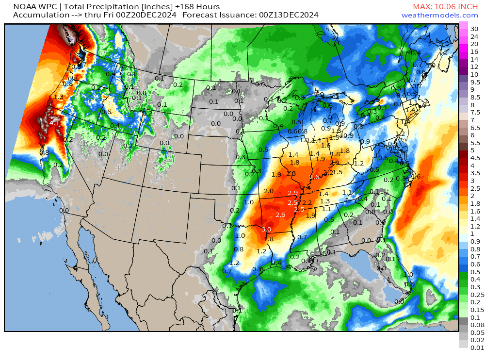
Heavy rainfall during middle of next week across the central Mississippi Valley with perhaps 2-3” from Little Rock to Indianapolis.
EPS 12z | 5-Day Chunk Temperature Anomaly
Days 1-5: December 12 - December 16

The cold air left behind from the ongoing mini-Arctic blast will wash out of New England into next week.
Days 6-10: December 17 - December 21

Day 8-12: December 19 - December 23

This 5-days average captures the next major trough and cold blast into next weekend (Dec 21-22)
Days 11-15: December 22 - December 26

Snowfall Analysis Last 7-Days

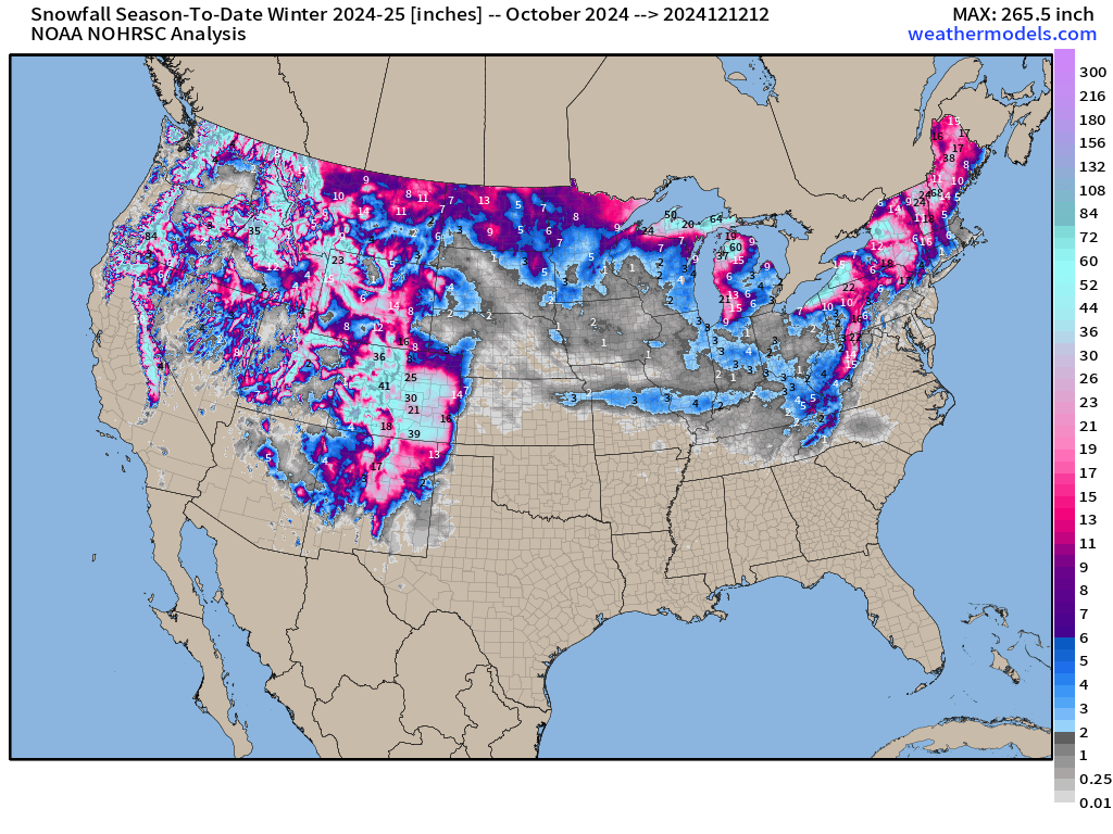
Snowfall Analysis Season to Date | October 1, 2024 — today.
Maps sourced from weathermodels.com designed and innovated by yours truly! Please subscribe there for real-time access to the newest maps, charts from all of the weather models including ECMWF.
That looks very much like a classic bomb cyclone but unusually powerful heading directly at us in Oregon. Hope the models are wrong.