


August 29, 2023 Hurricane Season
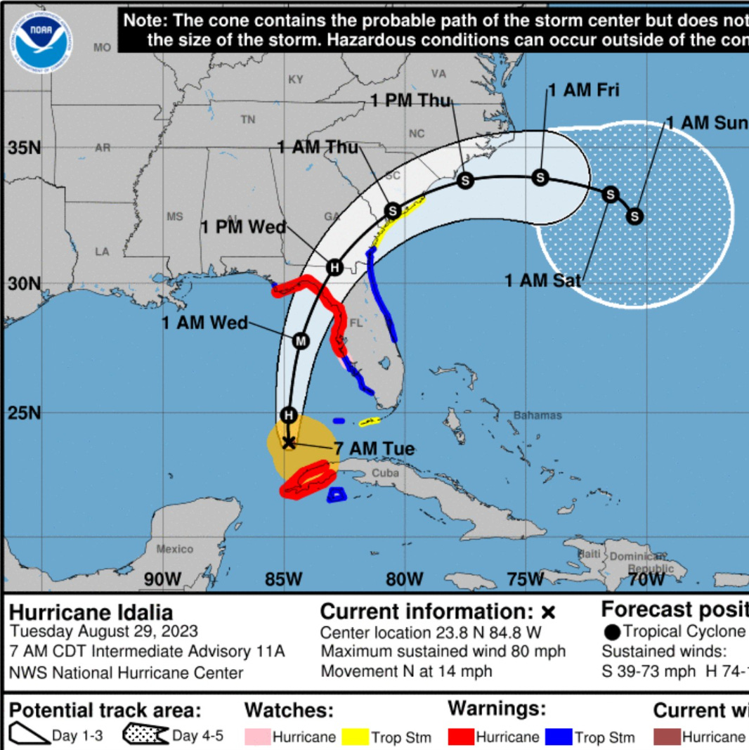
Hurricane Idalia poised to rapidly right up until landfall
Hurricane Idalia intensifying — extremely dangerous situation for Florida Big Bend coast from Apalachicola to Tampa Bay with storm surge piling up to 12-feet.
NHC 8 AM ET updated track brings the center of Idalia into Taylor County, Florida by mid-morning on Wednesday. The coastline is marsh with sandy soils well inland with forests largely covering the area. The population is 22,000 with the county seat being Perry, and is on the back-roads route from Tallahassee to Gainesville along US-27.
Idalia has another 24-30 hours of time to intensify over very warm/deep waters of Gulf of Mexico. Landfall intensity is forecast to be 105-knots (Category 3) but could be higher. Cat 4 is 115-knots.
Threats: Rainfall and flooding: 8-10 inches of rainfall expected near the core of Idalia in the Taylor and Dixie County coastline of Florida’s Big Bend with about 4” in Tallahassee and 2-4” in Jacksonville and Gainesville. Heavy rainfall will extend through SE Georgia into the Carolinas for a significant inland flooding threat. Overall rainfall across the SE states affected by Idalia will be 10-12 Trillion gallons similar to Hilary.

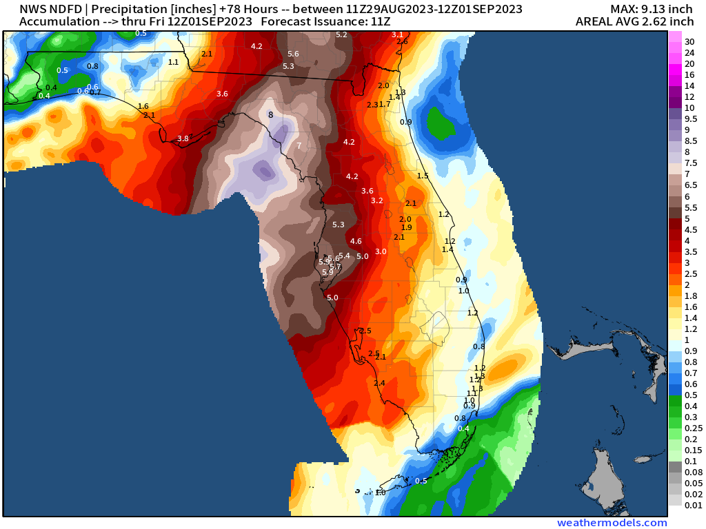
Winds: Hurricane force winds and stronger gusts will extend about 50-75 miles away from the center of Idalia mainly on the right (eastern) side of the track. The current NWS maximum forecast wind gusts shows hurricane force wind gusts possibly extending to the Atlantic coast of Georgia. Strong winds in Jacksonville, Florida are also a possibility. A slight change in the forecast track of Idalia could expose significant populations — and trees — to hurricane force winds with Tallahassee on the western edge, and Gainesville on the eastern.


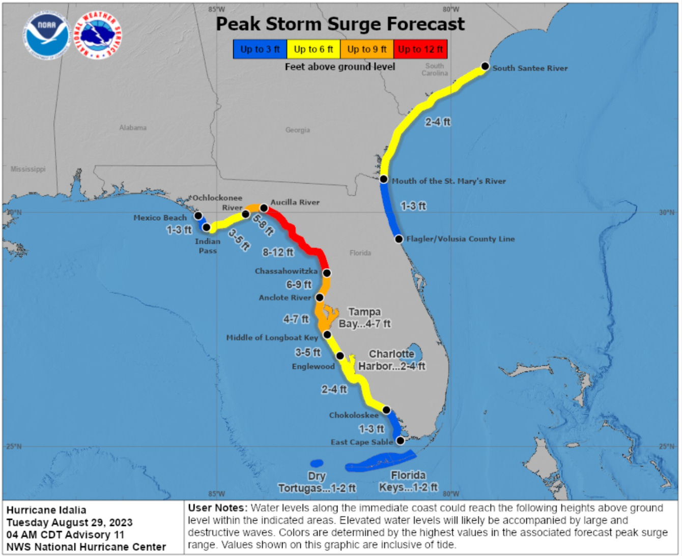
Peak storm surge: Tampa Bay to see 4 to 7 feet of storm surge. Up the coast in the Big Bend 8 to 12 feet along Taylor and Dixie Counties. Also, Franklin and Wakulla Counties could see 3-8 feet of storm surge as Idalia pushes water onshore.
Short term Atlantic Tropics
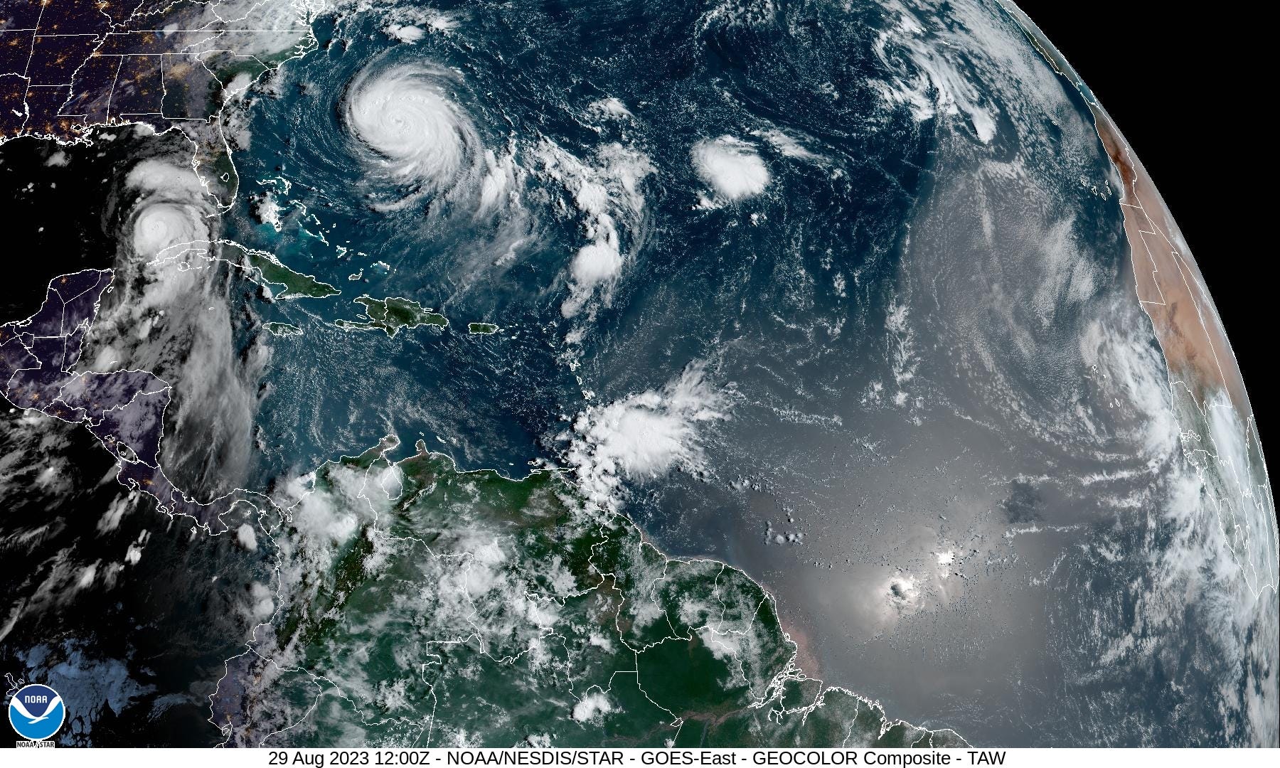
Major Hurricane Franklin remains a powerful Category 4 hurricane (120-knots) as of 5 AM ET Tuesday morning. Franklin is moving slowly waiting for a trough to pick up the storm and accelerate to the ENE. While tropical storm force winds may impact Bermuda, the island will largely escape direct impacts. Large waves and swell continue to impact the East Coast with dangerous rip currents.
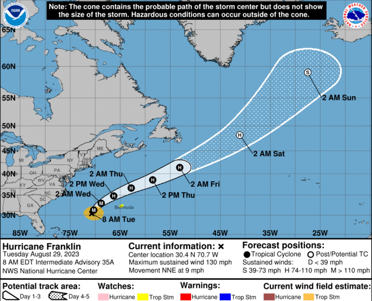
Compare the sizes of Franklin and Idalia. Over the next 24-hours, we may have two coincident major hurricanes.
Medium Range Atlantic Tropics
Keep reading with a 7-day free trial
Subscribe to Weather Trader to keep reading this post and get 7 days of free access to the full post archives.