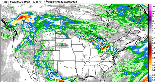
Top stories Tuesday morning: (1) Tropical Storm Harold makes landfall in South Texas bringing heavy rain well inland across the Rio Grande Valley.
(2) Monster “heat dome” in the central U.S. continues to blast furnace many states with 100°F heat continuing in the Southeast through the weekend. The ridge has trapped considerable near-surface moisture sending dew points in the 80s and heat index values to 120° or even 130°F around Lawrence, Kansas. That’s oppressive.
(3) Tropical Storm Franklin in the Caribbean will cross Hispaniola and stew in the Atlantic for several days. Slow northward movement will accelerate after becoming a hurricane. It could be intense.
(4) Potential Gulf of Mexico system next week. Models have hinted at a system coming from Central America over the Yucatan and spinning up in the very warm Gulf.
Heat Dome breaks down eventually
Extreme heat continues across the Gulf coast and Southeast states through the weekend, but thankfully, cold fronts and Northwesterly flow breaks down the heat dome. If we can get into September, then hopefully the worm will turn for much cooler weather as Fall quickly descends upon the Lower 48.
Rainfall around the heat dome is associated with remnants of Hilary in the northern Rockies and Tropical Storm Harold in south Texas. The Great Lakes and Northeast may only see a glancing blow of heat before returning to comfortable 70s and 80s by Sunday.
The Atlantic quickly burned through names on the list
Keep reading with a 7-day free trial
Subscribe to Weather Trader to keep reading this post and get 7 days of free access to the full post archives.


