


April 3, 2024 Nor'easter Buries New England in Heavy Snowfall
Quiet and cool weather across the central Lower 48


The second act of the double-barrel low pressure system is pounding New England with heavy rain and snow. Total QPF is in the 2-3 inch range, and temperatures are certainly cold enough for heavy, wet snow away from the coast. Boston may see some mix or ice pellets, but unlikely any snow accumulations.
Huge snow totals across NH/VT/ME with 12-18” or even 24” at higher elevations.
Wednesday Evening Temperatures 7:30 PM ET
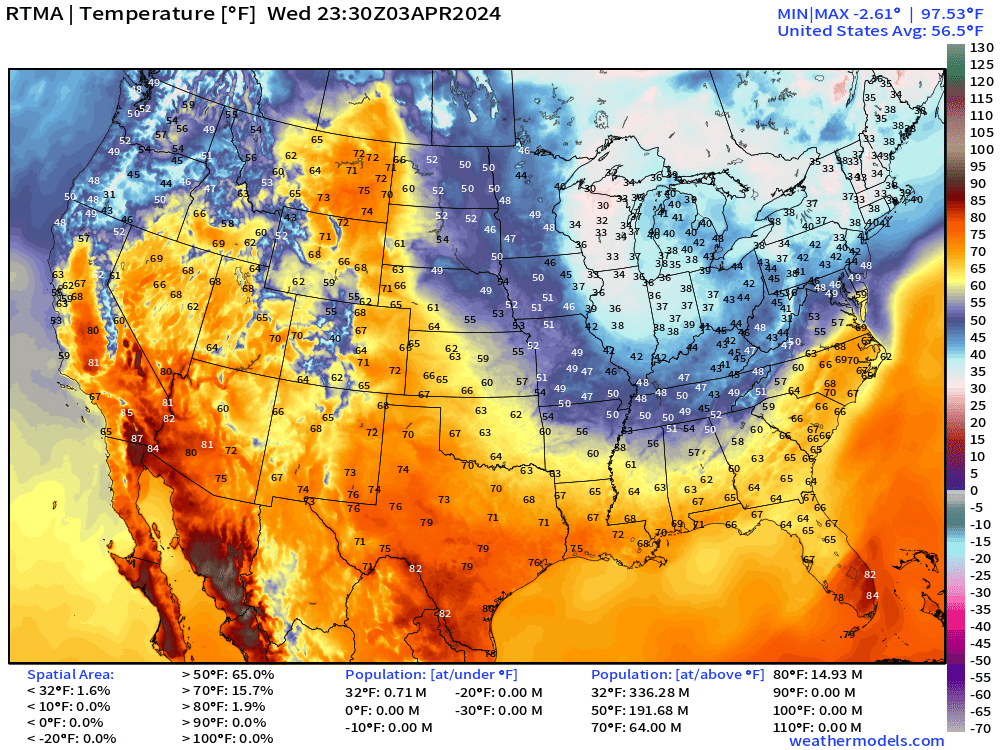
Under the cloud cover and snow showers in the Great Lakes, temperatures are stuck in the 30s as far south as Indianapolis making for a very raw early April / Spring day.
Also, only in the 30s across New England.
Nice and warm in Montana in the 70s, and the Southwest including Phoenix nicely in the 80s.
Thursday Weather

The Nor’easter cranks all day on New England with blustery, chilly rain or heavy snowfall. The cold front clears Florida into Cuba with clearing skies and chilly Canadian air dipping into the Southeast for a few days. Fair weather will dominate until the next storm system takes shape from moisture and energy coming onshore the West Coast. .
Thursday High Temperatures
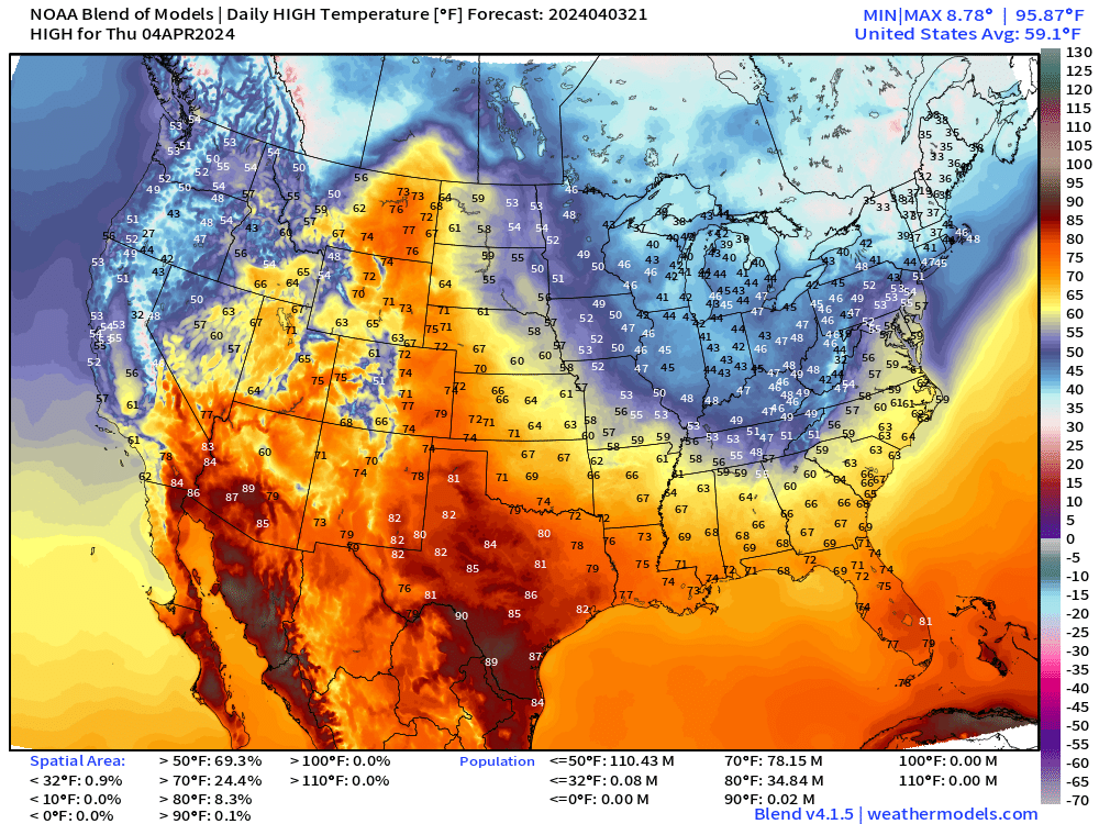
The trough across the Eastern U.S. dips into the Gulf Coast with mild temperatures only in the lower-70s in Tallahassee, 60°F in Atlanta, and mid-50s in Nashville. It might be a while before we see warmth like this last weekend.
Total Solar Eclipse Cloud Cover

Reminder that total cloud cover is often misleading with high clouds dominating the layers. For 18z on Monday, the only “bad” spots would be where low clouds and rainfall are occurring along the frontal boundary.
The high clouds are likely way overdone in the ECMWF HRES cloud layer scheme, so Austin/Dallas Texas remain just on the edge of perfect conditions for totality vs. incoming clouds and rain. The rest of the path of totality looks almost perfect.
Next 8-Days Weather Systems

Nor’easter spins off New England coast into the weekend with ugly, blustery conditions.
Much cooler air behind a cold front by this weekend as the storm systems exit the stage. Then we are on Total Solar Eclipse Watch
Heavy rain across the Texas — Louisiana with flow off Gulf of Mexico by next Wednesday, as indicated in the WPC 7-day forecast
3-Days Total Snowfall | NWS NDFD

Mount Washington with 3-feet of snow. Large area of 12”-18” across NH and Maine with more at higher elevations. Boston could see a dusting, but probably nothing sticking.

The total QPF is considerable with 1.5” to 2.5” from NYC to Boston and up to 3”, which will be mostly snow along NH/Maine border.
WPC 7-Day Precipitation Forecast
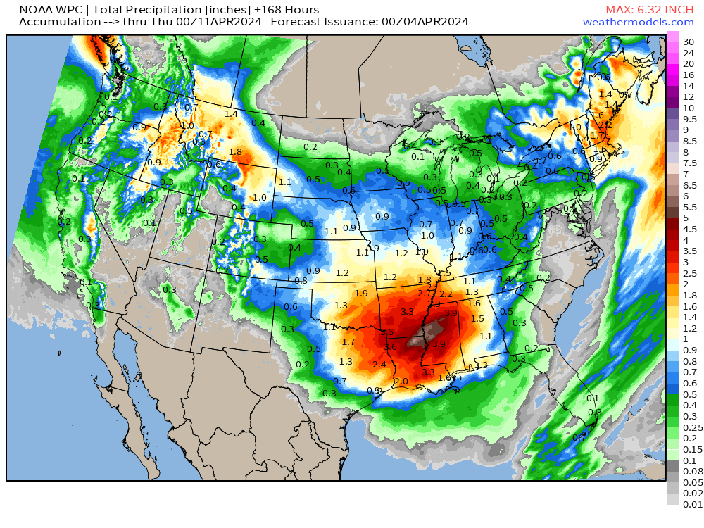
WPC has a 6” of rainfall area over LA/MS and 3” stretching around it with next storm system by middle of next week.
ECMWF HRES 7-Day Snowfall Forecast

The Western U.S. still with significant snowfall accumulations in the Rockies as well as the Sierra.
Hopefully after the Nor’easter spins away this weekend, that will be the end of Great Lakes and New England snowfall. I’ve said that before and been way wrong.
ECMWF Ensemble 5-day Temperature Anomaly Chunks
Next 5-Days From April 3-7
Chilly across the West Coast and east of the Mississippi as two troughs bowling ball their way through the Lower 48.

Days 6-10 From April 8-12
Well above average across Canada and east of the Mississippi

Days 11-15 from April 13-17
Western Warmth!

Thank you to Subscribers and Supporters! Almost the growing season — so much is going on in the world of weather!
Maps sourced from weathermodels.com designed and innovated by yours truly! I actually create all of my content from scratch.